New elevation mapping gives fresh insights into parts of Waitaha
Waitaha Canterbury can now be viewed in 3D thanks to new data from a ground-breaking aerial laser survey of the region.
The entire coastline from Waiau-toa Clarence River to Waimate was captured between January and December 2020 as part of the NZ National Elevation Programme — a collaboration between us and Toitū Te Whenua Land Information New Zealand (LINZ).
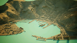
LiDAR-derived visualisation of Lyttelton Port
The data, which is now publicly available, will be used to generate high-definition 3D maps and models that will deliver a range of benefits for Waitaha, particularly in environmental planning and management, managing natural hazards, planning of services and infrastructure, and tracking changes to coastlines and rivers.
The data is the first release of the 2019-2025 Canterbury LiDAR (light detection and ranging) capture project, while data for the rest of the region will be released as it becomes available.
"In 2016, Toitū Te Whenua LINZ, in partnership with regional councils, began a project to procure and make available a nationally consistent baseline elevation data set for New Zealand. By 2024, about 80 per cent of the country will be covered by highly detailed elevation data and will be freely available under an open licence," said LINZ location data analyst Emory Beck.
"The data that LiDAR generates are invaluable in understanding and preparing for natural hazards, as well as informing infrastructure management, hydrology, catchment planning, and in many other applications."
A fundamental tool to understand our land
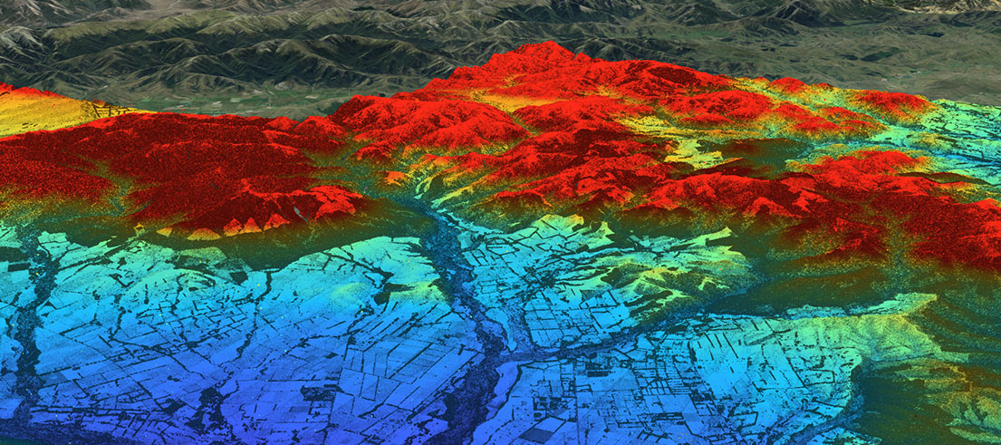
Elevation data or LiDAR is a technology using laser sensors mounted on aircraft that fly over a landscape to capture a 3D view of the land.
Because the sensor can rapidly pulse a laser beam, it can capture a 'point cloud' of highly accurate 3D measurements — like a digital twin of the landscape.
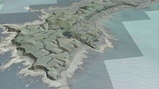
Kaikōura Peninsula in 3D
The data represents a wealth of information that can help us understand our land, boost economic performance, and improve our resilience to hazards and climate change.
Our senior scientist Callum Margetts said LiDAR is fundamental to his team's process for mapping flooding, tsunami, and coastal erosion across our region.
"With climate change and rising sea levels predicted to increase the severity of extreme weather events, it's important that we understand, in detail, which areas might be the most affected by natural hazards," he said.
"Accurate ground levels from LiDAR allow us to better regulate development, plan mitigations, and build more effective flood defenses.
"LiDAR allows us to map flooding with enough accuracy to recommend floor levels for new dwellings, to ensure that homes stay dry during large floods."
Regional lead river engineering Matthew Surman said his team uses LiDAR to analyse bed level and volume changes in rivers so that gravel extraction can be targeted to areas where bed levels have built up.
LiDAR can also be used for:
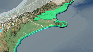
The entire coastline of Canterbury was captured as part of the NZ National Elevation Programme
- tracking our changing coastal environment to mitigate the impacts of climate change
- land surveying — survey benchmarks, local datum conversions and calculations
- capturing road centrelines/road crowns and footpaths
- identifying cultural and archaeological features
- feature extraction — building outlines and vegetation
- subdivision levels and drainage plans
- stormwater networks into drainage pits or wetlands
- sea wall or floodwall engineering
- natural hazards — liquefaction hazard delineation, tsunami modelling, landslide analysis
Dataset download
The new datasets are available for download from the LINZ Data Service:
To explore the new point cloud in 3D, check out our online web scene on Canterbury Maps. LAS Point Cloud and vendor project reports are also available on the OpenTopography website.
Visit LINZ’s Elevation Aotearoa website for more information about the NZ Elevation Programme.