Otipua-Saltwater Creek catchment
Otipua-Saltwater Creek is a popular waterway and a great spot for a walk or bike ride, home to the local rowing club, as well as native plants and wildlife. But issues with weed, water quality and flow levels mean that we need to carefully manage this water resource in the future.

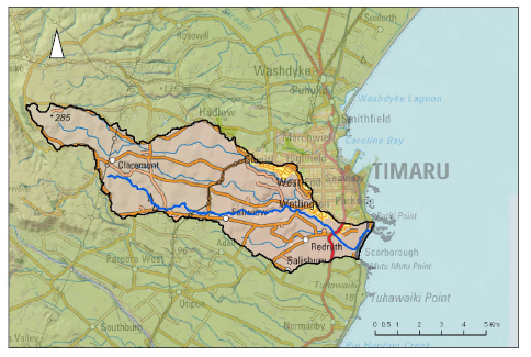
Where exactly is the Otipua-Saltwater Creek catchment?
This map (PNG file, 317 KB) shows the large catchment area which runs from rural farmlands in Claremont to the sea in south Timaru. Many people living in Timaru know the downstream areas well for its popular riverside recreational paths running to the sea.
The Otipua wetland, downstream of SH1 bridge on the right bank, provides habitat for birds and offers attractive public walkways.
This is a special place, full of wildlife!
Two group explorations of Otipua Wetland, from SH1 down to the seashore, were made in 2020 by visiting scientists and local volunteers, and their hundreds of observations, (photographs with species names and descriptions), are now published on the I-Naturalist website, where others have added more observations.
Take a virtual fly-over
Explore the catchment from the air by watching a virtual fly-over video of the different tributary streams, each time starting at the sea near Redruth and travelling inland.
These short videos are a great resource to help us to better understand the catchment, including potential sources of erosion of silt and sediment into the creek.
Rural and urban issues
Both rural and urban communities can work together to improve water quality at Otipua-Saltwater Creek.
Rural issues
Rural septic tank system overflows send nutrients and bacteria, as can dairy effluent-spreading and any points where stock have direct water access. The local clay-rich Loess soils erode easily, which means that flood flows can shift large volumes downstream if banks are steep and exposed. Farm waste materials and agricultural chemicals could pollute water, as can livestock access.

Bank collapses are a risk in the loess clay, when it is steep. This one on Otipua Creek was repaired by the farmer using rocks.

In the upper catchment the streams are often dry but fill fast after rain. This can cause a flash-flood, washing tree branches and grass into fences. Nutrients and bacteria from the paddock surface are washed in too.
Urban issues
A significant part of South and West Timaru's housing land and Redruth industry drains its road surface and roof water into the catchment. This stormwater carries litter such as plastics and cigarette butts, zinc from galvanised roofs, copper worn from car brake-linings, rubber and oils washed off road surfaces, detergents from car washing, berm lawn weed-killers, etc.
Other environmental issues
Other environmental issues, such as 'blooms" of algal growth, flood and drought-related impacts on flow also affect the waterway and those who use it. The Timaru Rowing Club has been finding that the summer water level is too shallow for their sport.
The in-stream fish and insect life here is not very complex or diverse compared to upland streams. There are no trout or salmon, but eels and perch are present.
What are we doing?
The Otipua-Saltwater Creek informal Catchment Group was established to provide an opportunity for local people to connect and contribute to the improvement of this unique urban and rural waterway.
Whether you're a cyclist, dog-walker, farmer or an interested community member, you're always welcome to come along to events and find out more about the Catchment Group.
Otipua-Saltwater Creek Catchment Group’s actions include:
- celebrating what we value about Otipua-Saltwater Creek and its tributaries
- sharing information for all landowners on good management practices that protect water quality
- arranging farm visits and looking for in-stream life
- volunteering help for water-side (riparian) planting
- encouraging industry and household actions to improve urban stormwater.
The informal catchment group was formed after recommendations from a joint working group set up in 2017, to provide an information base and establish a shared commitment. This included representatives from Environment Canterbury, Timaru District Council and the Department of Conservation, members of local rūnanga of Ngāi Tahu, Fish and Game Council, Timaru Rowing Club, and a local farming family.
Join the Otipua-Saltwater Creek Catchment Group mailing list
Read Environment Canterbury's privacy policy. This form is protected by reCAPTCHA and the Google privacy policy and terms of service apply.