Farming land use consent
Some types of farming activity – or farming activities in areas with sensitive receiving environments – bring higher environmental risk. Our regional and subregional plans have defined which activities in which areas require farming land use consent.
Resource consent grants the right to undertake certain farming activities that would otherwise be prohibited in the area.
In return, the consent holder is required to meet certain conditions to ensure the environmental impact of their farming is minimised.
These conditions go above regular good management practices and may include:
- prohibitions on some high-risk activities,
- restrictions on intensifying land use, or
- the need to meet greater nutrient loss reductions.

Photo credit: Tracey McNamara
Check if you require farming land use consent
The triggers for land use consent are set by rules in the Canterbury Land and Water Regional Plan (LWRP) and associated plan changes. Thus, they vary across the region according to factors like the scope and size of the farming operation and the receiving environment.
The original LWRP contained rules based on nutrient allocation zones, which apply across much of North and Central Canterbury. Subsequent plan changes have introduced different farming land use triggers in sub-regional areas.
Note: Some irrigation schemes have a global land use consent that manages nutrients on behalf of its users. Check with your scheme if you’re unsure whether they have a global consent that covers your farm.
How to use the maps to determine if you need consent
We have created the following maps for you to determine if your farm falls under the regionwide and/or specific farming land use rules. To use the maps:
- view the appropriate map for your part of Canterbury
- zoom and scroll to your farm's location or search by address (click on the magnifying glass in the right-hand corner and type the address in the field)
- click on the legend icon under the magnifying glass to find the colour description that corresponds to the rule set for your farm’s location
- read the specific farming land use rules for your area to find out whether you require resource consent.
North Canterbury farming land use rules
Farming land use rules for North Canterbury
After identifying which rules apply to your farm read the farming land use rules listed for northern Waitaha/Canterbury.
Read the regionwide rules of the LWRP nutrient allocation zones (light blue, green, orange, red or purple areas)
If your land is in a regionwide nutrient allocation zone, you will not need consent if:
- your farm is under 10 hectares; or
- you have a water permit for irrigation, granted before 18 January 2014, with conditions that limit the amount of nitrogen that may be leached and requires the preparation of a plan to mitigate the effects of nutrient loss to water.
If the above does not apply, you will need a land use consent to farm if:
In a lake zone (purple):
- your property is greater than 10ha
In all other areas (light blue, green, orange or red):
- your farm has 50 hectares or more of authorised irrigation; or
- you have an area of winter grazing that exceeds the limits in the table below; or
| On a property | Winter grazing area |
|---|---|
| Less than 100ha | 10ha or more |
| Between 100ha and 1000ha | 10% of the property or more |
| More than 1000ha | 100ha or more |
- your farm is within the red “Water quality outcomes not met” area and your irrigated area has increased by more than 10ha since 13 February 2016.
Read the rules from the Hurunui Waiau River Regional Plan - Nutrient management area (Red hashed lines)
The Hurunui and Waiau catchments have their plan outside of the LWRP, known as the Hurunui Waiau River Regional Plan.
The Permitted Activity rules for farming activity in the region are contained in Section 3.3 of the plan (pages 27–28). If you are unable to meet these rules, talk to your farm advisor or contact our consent team about whether you can change your operation to meet the Permitted Activity rules or apply for resource consent.
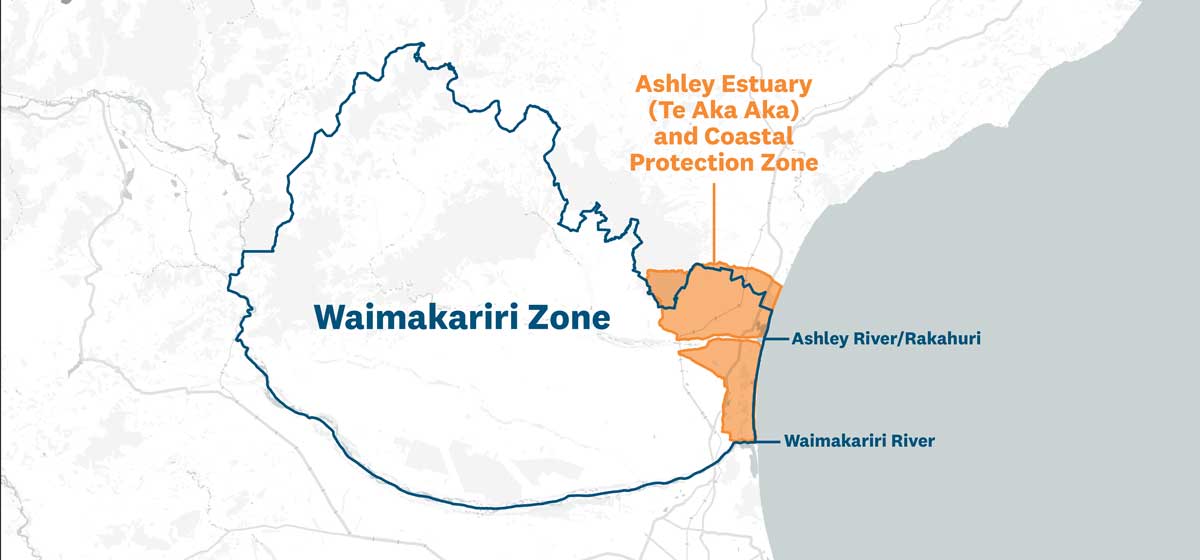
Read the rules for the Waimakariri water zone (pink and light green)
You will not need consent if:
- your farm is less than 5 hectares; or
- your farm's nutrient loss is managed under the Waimakariri Irrigation Ltd scheme resource consent.
If the above does not apply, you will need a land use consent to farm if:
- you have more than 50 hectares of irrigation; or
- you have under 50 hectares of irrigation but you have increased your irrigated areas by more than 10 hectares since 20 July 2019; or
- you have an area of winter grazing that exceeds the limits in the table below; or
| On a property | Winter grazing area |
|---|---|
| Less than 100ha | 10ha or more |
| Between 100ha and 1000ha | 10% of the property or more |
| More than 1000ha | 100ha or more |
- your farm is larger than 5 hectares in the Ashley Estuary (Te Aka Aka) and Coastal Protection Zone (light green area), contains a river or coastal lake on the farm or next to the farm boundary and has any irrigation or winter grazing.
Central Canterbury farming land use rules
Farming land use rules for central Canterbury
After identifying which rules apply to your farm read the farming land use rules listed for central Waitaha/Canterbury.
Read the regionwide rules of the LWRP nutrient allocation zones (light blue, green, orange, red or purple areas)
If your land is in a regionwide nutrient allocation zone, you will not need consent if:
- your farm is under 10 hectares; or
- you have a water permit for irrigation, granted before 18 January 2014, with conditions that limit the amount of nitrogen that may be leached and requires the preparation of a plan to mitigate the effects of nutrient loss to water.
If the above does not apply, you will need a land use consent to farm if:
In a lake zone (purple):
- your property is greater than 10ha
In all other areas (light blue, green, orange or red):
- your farm has 50 hectares or more of authorised irrigation; or
- you have an area of winter grazing that exceeds the limits in the table below; or
| On a property | Winter grazing area |
|---|---|
| Less than 100ha | 10ha or more |
| Between 100ha and 1000ha | 10% of the property or more |
| More than 1000ha | 100ha or more |
- your farm is within the red “Water quality outcomes not met” area and your irrigated area has increased by more than 10ha since 13 February 2016.
Read the rules for the Hinds Hekeao Plains area (green hash lines)
You will need consent if:
- your farm is larger than 5ha and your nitrogen loss calculation exceeds 15 kg/ha/yr.
Read the rules for the Selwyn PC1 area, including the Phosphorus Sediment Risk Area and Te Waihora Cultural Landscape/Values Management Area (pink, yellow hash lines and blue)
You will need consent if:
- your farm nitrogen loss calculation exceeds 15 kg/ha/year; or
- your farm is 10 hectares or larger and any part of your property is within the Te Waihora Cultural Landscape Values Management Area (blue) or the Phosphorus and Sediment Risk Area (yellow hash lines).
South Canterbury farming land use rules
Farming land use rules for South Canterbury
After identifying which rules apply to your farm read the farming land use rules listed for southern Waitaha/Canterbury.
Read the rules for the Orari-Temuka-Opihi-Pareora zone (light blue, purple, pink and yellow outline)
You will not need a consent if your farm is under 10ha.
If your farm is larger than 10 hectares, you'll need a land use consent to farm if:
- your farm has 50 hectares or more of authorised irrigation; or
- you have increased your irrigated area by more than 10ha since July 2019 or;
- any part of your farm is located within the Rock Art Management Area (pink) and you have any area of irrigation, or you discharge water, or solid or liquid waste (for example, effluent); or
- any part of your farm is located within the Mātaitai and Waipuna Protection Zone (yellow outline) and contains or is next to a river or coastal lake, and you have any area of irrigation or winter grazing; or
- You have 20ha or more of winter grazing of cattle or deer within the High Runoff Risk Phosphorus Zone (purple)
- You have an area of winter grazing that exceeds the limits in the following table:
| On a property | Winter grazing area |
|---|---|
| Less than 100ha | 10ha or more |
| Between 100ha and 1000ha | 10% of the property or more |
| More than 1000ha | 100ha or more |
Read the rules for the Upper Waitaki Haldon and mid-catchment zones (orange)
You will not need a consent if you have a water permit for irrigation, granted before 18 February 2016, which has conditions that limit the amount of nitrogen that may be leached and requires the preparation of a plan to mitigate the effects of nutrient loss to water.
If the above does not apply, you will need consent if:
- your farm has 50ha or more of irrigation; and/or
- you have an area of winter grazing that exceeds the limits in the table below:
| On a property | Winter grazing area |
|---|---|
| Less than 100ha | 10ha or more |
| Between 100ha and 1000ha | 10% of the property or more |
| More than 1000ha | 100ha or more |
Read the rules for the Upper Ahuriri zone (pink hash lines)
You will not need consent if you have a water permit for irrigation granted before 18 February 2016. This permit has conditions that limit the amount of nitrogen that may be leached and requires the preparation of a plan to mitigate the effects of nutrient loss to water.
If the above does not apply, you will need consent if:
- your farm has 50ha or more of irrigation; or
- your farm has 20ha or more of winter grazing; or
- your irrigated or winter grazing land areas have increased since 13 February 2016.
Read the rules for the Hakataramea Valley and Greater Waikakahi (red) and Valley and Tributaries and Whitney’s Creek areas (blue)
You will not need a consent if you have a water permit for irrigation, granted between 1 November 2009 and 13 February 2016 that has commenced, and it has conditions that require the preparation of a plan to mitigate the effects of nutrient loss to water. You also can not have changed conditions to your water permit since 13 February 2016.
If the above does not apply, you will need consent if:
- your farm has 50ha or more of irrigation; or
- in the Hakataramea Valley and Greater Waikakahi (red) area you farm has 20ha or more of winter grazing; or
- in the Hakataramea Valley and Greater Waikakahi (red) area your irrigated or winter grazing land areas have increased since 13 February 2016; or
- in the Valley and Tributaries and Whitney’s Creek areas (blue) you have an area of winter grazing that exceeds the limits in the table below:
| On a property | Winter grazing area |
|---|---|
| Less than 100ha | 10ha or more |
| Between 100ha and 600ha | 10% of the property or more |
| More than 600ha | 60ha or more |
Read the rules for the Morven Sinclairs Area (teal blue)
You will need a land use consent if:
- your farm is larger than 5ha; and
- your current nitrogen loss*exceeds your nitrogen baseline†.
*Current nitrogen loss: this is the rate of nitrogen loss averaged out over the most recent 1 July-30 June four-year period.
†Nitrogen baseline: this is the rate of nitrogen loss averaged out over the years of 1 July 2009-30 June 2013.
Read the rules for the northern streams and Waihao Wainono areas (lime green)
You will need a land use consent if:
- your farm is larger than 5ha; and
- you are on hill land, and the current nitrogen loss for your farm is greater than your nitrogen baseline and more than 5kg of nitrogen per hectare per year.
- you are on the plains, and the current nitrogen loss for your farm is more than 15kg of nitrogen per hectare per year and:
- greater than your nitrogen baseline; or
- greater than 35kg per hectare per year on shallower soil**; or
- greater than 25kg per hectare per year on deeper soil**; or
- greater than 20kg per hectare per year on wetter soil**.
*Current nitrogen loss: this is the rate of nitrogen loss averaged out over the most recent 1 July-30 June four-year period.
†Nitrogen baseline: this is the rate of nitrogen loss averaged out over the years of 1 July 2009-30 June 2013.
**If your property has more than one soil type, an 'area-weighted average' needs to be worked out. The calculation is as follows: the sum of the maximum cap loads (where each load is calculated by multiplying the maximum cap by the area of land to which that cap applies) divided by the total area of land.
Use this Excel document (XLSX File, 23.07KB) to help with your area-weighted average calculation.
Applying for farming land use consent
If you've determined that your farming activity requires a Farming Land Use consent, there are a few things you'll want to do next.
Put together a Farm Environment Plan (FEP)
If you don't already have an FEP, you'll need one to form part of your consent application.
Visit our FEP webpage for more information on what needs to be in your FEP.
Get help from an expert
You don't need to employ a consultant to help you with your Farming Land Use consent application, but the information required can be difficult to put together, so consulting with a rural professional is advised.
- Your industry support group should be able to help you with advice and templates for putting together your FEP and consent application.
- We offer a free one-hour pre-application advice service. Fill out the form on this page to apply.
- Contact your local Land Management Advisor. They will be able to confirm whether you require consent and give you advice on how to begin your application process.
- Download the consent application form: Form 9: Application for resource consent (DOCX file, 250.36KB).