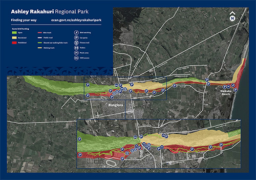
Ashley Rakahuri Regional Park
If you live in the Rangiora area or are looking for a day out in North Canterbury, Ashley Rakahuri Regional Park is the place to go for fishing, walking, swimming, cycling and family picnics.
Please check notices and events for the latest information or like our Facebook page to stay up to date.
How to get there
The Ashley Rakahuri Regional Park encompasses the Rakahuri Ashley River and berm area from the Okuku River confluence downstream to the Ashley Estuary.
There are multiple access points to the park, but the most popular are at the Rangiora/Ashley traffic bridge and State Highway 1 bridge.
The land within the Ashley Rakahuri Regional Park was vested in us to protect or create funds for river protection works so surrounding land can be protected from flooding.
About the park
The park includes pine forest blocks, mixed stands of exotic trees, including willows and poplar, and pockets of native vegetation that are gradually being restored and enhanced.
A variety of recreational opportunities are available at the park including fishing, swimming, gamebird hunting, walking, cycling and picnicking.
Dogs must be kept under effective control at all times.
No barbecues are provided but visitors are welcome to bring their own, provided they are gas-only and used in areas clear of vegetation. Light no fires. Dial 111 immediately if you see smoke or flames.
Entrances and car parking
- River Road, slightly west of the intersection with West Belt. Access roads lead to Groyne 1 and an intermediate point on the Rakahuri Trail. Parking is available at this entrance, and at the ends of these access roads.
- Ashley picnic entrance: Off Milton Avenue, which is on the east side shortly before the bridge over the Ashley Rakahuri River.
- Break Bank: this entrance is on Cones Road. It leads to two parking areas.
- Rail bridge: at the north end of East Belt.
- Rakahuri picnic area: entrance via the Ashley township.
Park activities
![]()
![]()
![]()
![]()
![]()
The Ashley Rakahuri Regional Park has shared use mountain biking/walking trails.
- Rakahuri Trail - An easy shared walking and mountain bike track running from Groyne 1, behind the racecourse, downstream to East Belt. Shorter mountain bike tracks can be found in the pine forest downstream from East Belt.
- Mike Kean Walkway - A 0.9km easy track from the Ashley Picnic Ground, east of the State Highway 1 road bridge, to the car park at the rail bridge.
- Mountain biking - Shorter mountain bike tracks are accessed from the Rakahuri Trail downstream of the rail bridge car park. They offer single-track mountain biking.
- BMX riding - The North Canterbury BMX Club tracks can be accessed off Milton Ave.
- Picnics - A range of sites at Ashley, Rail Bridge, Groyne 1, Waikuku Beach and more.
Game bird hunting and shooting
Only game bird hunting (including Canada geese and pigeons) is permitted at the Ashley Rakahuri Regional Park, including the riverbed.
Hunting rules
- Target shooting with all types of firearm is prohibited.
- The hunting of small game such as rabbits and possums by the general public is prohibited.
- Game bird hunting must only happen in the designated areas (see below).
- Only shotguns may be used.
- A valid Fish & Game licence must be held.
- Fish & Game regulations and the gamebird hunting code of practice must be adhered to.
- Please note: you do NOT require a Fish and Game licence for hunting Canada geese and pigeons but are required to adhere to open, restricted and prohibited hunting locations.
Game bird hunting areas
Open
- North bank - between SH1 bridge and Groyne 23 (including the riverbed)
- North bank - upstream from the Cones Road Bridge to the Okuku confluence (including the riverbed)
- South bank - upstream from Merton Rd/Groyne 2 to the Okuku confluence
Restricted
- Rakahuri Ashley Estuary - excluding the beach east of the sand dunes, dawn to 9am. ACCESS BY FOOT ONLY, NO VEHICLES
- North bank - between Rakahuri Ashley Estuary and SH1 bridge, including the riverbed, dawn to 9am. ACCESS BY FOOT ONLY, NO VEHICLES
- North bank - between Cones Rd and Groyne 23/Beatties Rd, (including the riverbed), dawn to 9am
- Rakahuri Ashley riverbed - from the Cones Road bridge to the SH1 bridge, dawn to 9am
Prohibited
- South bank - from the southern end of the Rakahuri Ashley Estuary through to Merton Road/Groyne 2.
Ashley Rakahuri management plan
Please note this management plan is under review and may not reflect current guidelines and regulations. If you have questions, please contact the Duty Ranger on 03 353 9007 or by email duty.ranger@ecan.govt.nz.
Ashley Rakahuri Regional Park Longterm Management Plan July 2016 (PDF file, 1.67MB).


