Rangiora Reach Masterplan
The Rangiora Reach Masterplan was finalised in 2022. It aims to deliver a cohesive landscape plan for a section of the Rakahuri Ashley River.
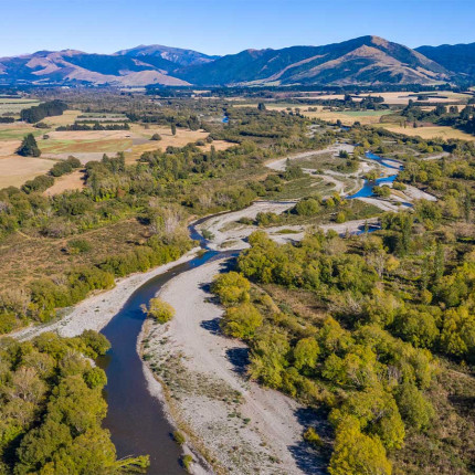
The masterplan will guide future development and management for the area of river from Dunlops Road to Beatties Road on the north side near Ashley; and Merton Road to Smarts Road on the south side near Rangiora.
It will be used by agencies managing this land – ourselves and Waimakariri District Council, in collaboration with mana whenua and the community.
The final plan reflects around two years of conversation, consultation, feedback, workshops, and hui we’ve had with the community. We hope it reflects people's values and priorities, but also helps meet the need to keep them safe through a changing climate.
Download the Rangiora Reach Masterplan (PDF File, 19.43MB)
This work contributes to our Whakahaumanu Ngā Awa ā Pākihi | Braided River Revival Programme and the draft Ashley River Rakahuri Revival Strategy.
Collaborative planning
As populations expand, new forms of recreation have developed, placing pressure and competing demands on the river and its ecology.
Collaborative and cohesive landscape planning is essential to ensure the multiple values of our rivers are considered. For the Rangiora Reach, these values include:
- Significance to Ngāi Tūāhuriri
- Ongoing flood protection
- Climate change
- Landscape and natural character
- Indigenous biodiversity
- Recreation
- Braided River Revival.
The masterplan development was supported by our Climate Resilience Programme (2021-2023), co-funded by the Ministry of Business Innovation and Employment’s Kānoa – Regional Economic Development & Investment Unit.

Background of the masterplan
- 2018 – A secondary stopbank was installed in the area of Ashley Rakahuri Regional Park adjacent to Cones Road to mitigate erosion risk - the narrowing of the river to fit under the bridge means a weak point is formed, increasing the water velocity and with it, the erosion risk.
- 2020 – Tree felling occurred in the Cones Road area, so it could function as a floodway if the primary stopbank fails – passing flood water around the road bridge and returning it to the riverbed downstream instead of flowing directly through the Rangiora township. The trees were also in poor health – rotten in the middle and unstable/hazardous to park users.
- 2022 – Community feedback following the tree removal expressed the high amenity, natural and recreational value placed on this area. Thus, the concept of the Rangiora Reach Masterplan was born in order to ensure future planning of the area took into account these values and that landscape planning was cohesive between us and Waimakariri District Council.
- 2023 - Consultation took place across 2022 and 2023. First to formally gather the values that were important to the community (March 2022), then again to share the draft masterplan for feedback (November 2022). The final masterplan was released in December 2023.

Implementing the masterplan
Throughout the consultation process, many people told us that they would like to see planting carried out in the Cones Road area during the 2022 planting season if it could be done in a way that will not hinder the flood overflow function of the area.
While we couldn't replant the entire area, we found that we were able to install smaller, deliberately located, nodes of low-height natives that will fold over in a flood, with a small number of well-maintained shade trees for the community's enjoyment.
Around 3,000 plants were planted by staff, contractors and the community.
We will continue to work with Waimakariri District Council and community to implement the masterplan as funding becomes available.
