Current river works
Here you can find information on our current river maintenance works we are undertaking across the region through targeted rates from river rating districts.
This includes operational tasks such as:
- weed control
- tree maintenance or removal
- infrastructure inspections.
Monthly river works plan: We also provide a monthly work plan that provides an overview of upcoming and current river works operations by area and river. Download the work plan—Kaikōura to Waitaki February (PDF file, 571.71KB)
Annual work plans: Find out what flood protection and drainage scheme maintenance activities are planned in your rating district from July 2025 to June 2026. Download work plans: southern region (PDF file, 2.7MB), northern region (PDF file, 1.86MB), central region (PDF file, 3.7MB)
Need more information or help? Contact our customer advisory team via our online form or call 0800 324 636.
Note: Dates given are indicative, as weather may delay work completion.
Native planting and stopbank maintenance along the Ōpihi River in Fairlie
Starting in July 2026
In late July and August, we will plant around 1210 native plants at two sites along the Ōpihi River in Fairlie. A total of 1,000 plants will be planted between Talbot Road and Ōpihi Gorge Road, building on planting work that has taken place there in recent years. A further 210 plants will be planted near the SH79 Ōpihi River Allandale Bridge to replace some plants that need to be removed from the nearby stopbank as part of planned maintenance work.
Some of the plants being removed were planted by community volunteers. While these plantings were well-intentioned and provide environmental benefits, trees and larger shrubs are not suitable on stopbanks because they can weaken the structure over time and reduce its ability to protect nearby homes, farms and infrastructure during flood events.
Planting 210 native plants nearby will help maintain the area's ecological and amenity values while ensuring the stopbank can continue to provide flood protection for the community.
Before planting begins, an excavator will be used to prepare the site near the SH79 bridge.
Access to the work area may be limited while work is underway for health and safety reasons. Any restrictions will be clearly signposted.
- WHAT: Site preparation and native planting.
- WHERE: Ōpihi River, on the true left berm immediately upstream of the SH79 Ōpihi River Allandale Bridge and the true right berm between Talbot Road and Ōpihi Gorge Road.
- WHEN: Site preparation and native planting in late July and August 2026.
- Stopbank maintenance work planned for October.

Figure 1: Approximate works area highlighted in red, 210 native plants will be planted at this site. Figure 2: A further 1,000 native plants will be spread in blocks throughout the area highlighted above, adding to previous planting efforts in this area.
Temuka River berm vegetation mulching and tree clearance – Winter 2026
WHAT:
Environment Canterbury will be carrying out vegetation mulching and tree clearance in several areas along the true left berm of the Temuka River.
The work is designed to improve the river’s ability to safely manage flood flows and increase the resilience of the berm during high river events.
Some areas will also be cleared in preparation for planting several thousand native and flood-protection plants.
These plantings will increase vegetation cover and diversity, helping to strengthen the berm over time.
WHEN: 20 July to 17 August 2026
WHERE: Temuka River berm, near Temuka Domain and Temuka Golf Course
Temporary signage will be installed before work begins, and some areas will be closed to the public while work is underway. We ask people to follow all signage and stay clear of active work sites for their safety.

Map showing the vegetation mulching and tree clearance work areas at Temuka Domain for winter 2026.
Channel maintenance and native planting on Twenty One Drain
WHAT: We will be undertaking drainage channel maintenance and site preparation works within a coastal drainage channel between the Ashburton and Rangitata rivers.
The works involve clearing and processing woody material, improving access and preparing the site for riparian native planting.
Native planting will take place later this winter in August to increase indigenous vegetation cover and long-term shading and habitat values.
WHEN: July - August 2026
WHERE: Twenty One Drain, downstream of Ocean View Road

Channel maintenance and native planting area on Twenty One Drain
Stream maintenance work underway on Taumatakahu Stream
WHAT: We’re carrying out mechanical stream maintenance in sections of Taumatakahu Stream in Temuka. The work includes:
- removing aquatic weeds and vegetation where needed
- removing in-stream and overhanging trees where needed
- clearing debris and other blockages affecting water flow.
Excavators and other machinery will work within the stream and from nearby access points.
WHEN: 15 - 26 June
WHERE: Work is taking place in sections of Taumatakahu Stream, as shown on the maps.
WHY: This work helps to:
- improve how the stream carries floodwater
- reduce the risk of blockages from vegetation and debris
- maintain the drainage and flood protection network
- improve resilience ahead of heavy rainfall.
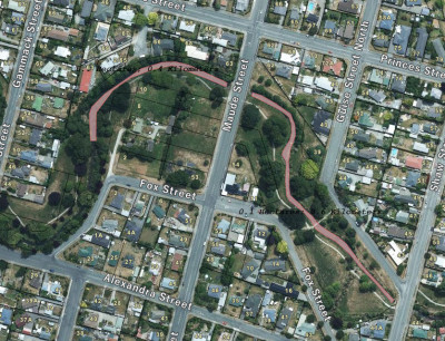
Taumatakahu Stream maintenance area near Maude Street and Fox Street, Temuka
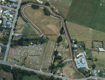
Taumatakahu Stream maintenance area near Milford Clandeboye Road and Temuka Cemetery
Takapō River tree removal
WHAT: Contractors for Environment Canterbury and Mackenzie District Council will be removing selected trees and vegetation along the true left of the Takapō River.
Work will include:
- Removing selected trees and vegetation
- Clearing debris from the river corridor
- Processing material on site at a skidding site off Highfield Road
- Removing usable wood from site
- Chipping and spreading smaller material on site
- Reinstating the site once work is complete
WHEN:
Work is expected to begin soon and will take several weeks to complete.
Work will take place during daytime hours, Monday to Friday.
WHY:
This work will help:
- Reduce fire risk to nearby homes, visitors and recreation areas
- Limit the spread of wilding conifers along the river corridor
What to expect:
During this time you may notice:
- Machinery operating in the river corridor
- Increased vehicle movements near access points including Highview Lane
- Temporary noise and disruption
- Temporary restrictions to some public access areas to keep people safe

Tree maintenance work along the Takapō River
Tree maintenance work in Ashley Rakahuri Regional Park
WHAT: Removal of hazardous and damaged trees.
WHERE: Ashley Rakahuri Regional Park.
WHEN: Beginning 25 May 2026, for approximately four days.
To keep the park safe, our contractors will be in the area (refer to the below map) removing hazardous and damaged trees. This includes any that are leaning, structurally compromised, dead or dying, or have unstable limbs.
A section of the vehicle access track will be temporarily closed while work is in progress. Walking and cycling tracks will remain open. Please take care around the work area and follow any signage or contractor instructions.
You may notice vehicles in the area and hear some noise while the work is underway.
Within the area marked in red on the map, all trees and debris will be removed due to the trees being compromised and hazardous. Following the works, these areas will be replanted with native species.
Within the area marked in green, dead trees, unstable limbs, and associated debris will be removed to improve public safety and overall tree health.
Material from the works will be mulched on site where appropriate. We’ll take care to minimise disturbance to residents and park users.
This work helps keep the berm safe for everyone who uses it. We appreciate your patience while it’s completed.

Tree maintenance work in Ashley Rakahuri Regional Park
Kowhai River tree clearance
WHAT: Removal of large trees near Kowhai River
WHERE: Kowhai River, Near Kowhai Ford Road
WHEN: 1st of July until 31st July
WHAT: In July we are starting a program to remove large trees that are impeding into the stopbanks on the north side of the Kowhai River. Works will extend 500m downstream of Kowhai ford road and 2500m upstream.
We will be utilising a local forestry crew while they are in the area. Works will involve the mechanical felling and mulching of trees directly adjacent to the stopbanks.
Trees growing on or near stopbanks are liable to fall during weather events and potentially damage the stopbank and impeding access for flood monitoring.
Access to the river may be limited while the work takes place for health and safety reasons.
Please comply with all signage and directions of staff on the ground.

Removal of large trees on Kowhai River, near Kowhai Ford Road
Opihi River Berm – Vegetation Clearance for Native Planting
WHAT: We will carry out mulching and vegetation scraping using a tractor mounted mulcher and an excavator to clear vegetation, in preparation for native planting as shown on the attached site plans. The purpose of native planting at these sites is to improve vegetation density and vegetation diversity, and to help manage weeds in the long term by establishing permanent shade. During site preparation, the Contractor will install signage and close river access tracks if required.
WHERE: Two sites on the true right berm of the Opihi River. The first is adjacent to the corner of Opihi Road and Opihi School Road around the waterway joining the Opihi River at this point. The second is downstream at Mill Road.
WHEN: Site preparation is expected to take place between mid-August. The expected duration of works is two to four days during this period.

Left map: Approximate vegetation clearance area (mulching) at Site 1 near the corner of Opihi Road and Opihi School Road on the true right berm of the Opihi River.
Right map: Approximate vegetation clearance area (excavator) at Site 2 at Mill Road on the true right berm of the Opihi River.
Hakatere Lake Hood Berm
Where: Above Lake Hood, true right berm. The site will be accessed via Boundary Road.
What: We will carry out mulching and vegetation scraping using a tractor-mounted mulcher and an excavator to clear vegetation, in preparation for native planting as shown on the attached site plan. The purpose of native planting at this site is to improve vegetation density and vegetation diversity, and to help manage weeds in the long term by establishing permanent shade.
Two areas of approximately 2500m² each will be cleared and planted under the willow canopy, within the areas shown by the green polygons on the site plan. One or two areas, totalling 1000m² will be cleared for geotextile planting as shown by the blue polygons on the site plan. During site preparation, the contractor will install hazards and safety signs at both ends of the walking track and will have a spotter present. The track may need to be closed for a couple of hours on two separate days to allow machinery to access and leave the site.
When: Site preparation will take place in late April and May this year and is expected to take five days. Planting will be carried out between mid-June and mid-August 2026 over two to three weeks.

Hakatere Lake Hood Berm - Site Preparation for Native Planting and Native Planting
Rakitata/Rangitata South Branch stopbank construction
Where: South Branch of the Rangitata/Rakitata River, to the west of SH1, near Arundel-Rangitata Rd
What: We will be constructing new stopbanks at three locations (shown in Figure 1) on private land. The works also include realigning an existing stock water race and installing two new culverts. The gravel used to construct the stopbanks will be taken from the main branch of the Rakitata/Rangitata River, north of the site.
These works are designed to improve flood protection for the local community by reducing the risk of overland flooding when the South Branch is flowing. This will help protect nearby homes, farmland, and
key infrastructure, including State Highway 1 and the railway line. Construction materials may be transported along public roads, and traffic management will be in place where required.
When: April 20th to end of June 2026, during dry weather.

Proposed new stopbank locations for Banks D, D2 and E along the Rangitata River
Okuku River fairway clearance
The Okuku River fairway tree‑clearance project will improve flood resilience by removing dead and overgrown trees and vegetation that restrict river flow and increase debris risk during high‑flow events.
The project is co‑funded by the Regional Infrastructure Fund, administered by Kānoa – Regional Economic Development & Investment Unit.
Where: Selected sections of the Grey and Okuku Rivers, including riverbed islands and identified choke points where vegetation and dead trees are restricting river flow.
What: The works will focus on clearing dead trees and vegetation from the riverbed, particularly from islands and narrow flow areas. This includes:
- Removing standing dead trees (including skeleton trees) and other vegetation from riverbed islands and large adult willow standing in the centre of the channel.
- Opening up choke points in the river to improve flow paths.
- Using machinery to carry out vegetation clearance in targeted areas.
- Considering limited gravel extraction where appropriate to support improved river capacity.
- Undertaking repatriation planting in any rebuilt berm areas once clearance works are complete.
- Managing and disposing of cleared material in line with environmental and safety requirements.
These works will help reduce the risk of debris build‑up and damming during flood events, lowering the potential for damage to bridges and other infrastructure.
When: Work starts the week of 26 January 2026 and will finish by end of June 2026, subject to weather and river conditions.

Ōkuku River tree clearance area of interest
Forestry Harvesting at ‘Grassy Banks’ site on Ōpihi River
WHAT: We are harvesting of around 27 hectares of poplar forest on the southern bank of the Ōpihi River. The area is being harvested for timber and will be replanted in another forestry crop, the species is to be confirmed.
Parts of the river, including access tracks and roads, will be closed to the public while harvesting takes place.
WHERE: The poplar forest is on the Southern side of the Ōpihi River at the top of Seadown Road, between the SH1 bridge and Waipopo Road.
WHEN: The harvesting crew are aiming to start on the week of 2 March 2026. The operation is expected to take 15 weeks.
WHY: These poplars were planted for flood protection. As they have matured, harvesting them is now the best way to manage the trees and make use of their value. The income generated will be reinvested into flood protection work across the Ōpihi catchment.

The area of work is in blue
Courtenay Stream floodgates construction
WHAT: Replacing the Courtenay Stream floodgates in Kaiapoi
WHERE: At the confluence of Courtenay Stream and the Kaiapoi River
WHEN: Work begins the week of 2 February 2026 and is expected to be completed by end of December
The current floodgates were built in the 1940s and are now due for renewal.
This upgrade is co‑funded through the Government’s Regional Infrastructure Fund (RIF), administered by Kānoa – the Regional Economic Development & Investment Unit. It also forms part of our 30‑Year Infrastructure Strategy (30YIS), which accelerates essential flood‑protection upgrades across the region.
The project includes removing the old structure and building new floodgates in the same location, starting with environmental controls, site setup, fencing, and public access changes. The upgraded structure will improve flood resilience, make maintenance safer for staff, and provide much better fish passage.
To keep the stopbank track open during construction, a temporary bridge will be installed over Courtenay Stream next to the work area.

The different work areas