Flood protection and drainage bylaw
We manage 58 river control and drainage schemes from Kaikōura to Waitaki, protecting a total asset value of $850 million.
The Flood Protection and Drainage Bylaw helps us manage, regulate and protect these assets, or those under our control, from inappropriate modification, damage or destruction and to ensure maintenance can be carried out to keep people and properties safe from flooding.
If you are planning work in a scheme area that we manage, you may require written authority (free of charge) before carrying out certain activities such as planting to ensure the activity doesn’t affect the integrity or effective operation of our schemes.
Infrastructure protected by the Bylaw includes, but is not limited to:
- Drains and small watercourses
- Floodways
- Defences against water including stopbanks, rock protection and groynes
- Floodgates and culverts
- Flood protection vegetation
- Hydrological devices and equipment
- Survey benchmarks.
The Bylaw was initially adopted in 2013 and subsequently reviewed in 2018.
Bylaw schedules and maps
The Bylaw applies to flood protection infrastructure in areas where Environment Canterbury has an established rating district for drainage and flood control schemes. These rating districts have been mapped in the schedules linked below.
The maps have been grouped into three Schedules, covering Flood Protection Schemes, Drainage Networks, or Floodways so a single location might be within one or more of the different group of schedules.
The Bylaw does not apply to privately owned drainage or flood protection schemes, or those managed by other local authorities.
Open the Main Stopbanks flood protection Index Map and click on the map number that you would like to view, or view each map individually (Maps 1–72).
Map 1 - Schedule 1 - Kaikōura Rivers (PDF File, 945.44KB)
Map 2 - Schedule 1 - Chatterton and Percival Rivers (PDF File, 951.4KB)
Map 3 - Schedule 1 - Conway River (PDF File, 1.897.9KB)
Map 4 - Schedule 1 - Waiau River (PDF File, 869KB)
Map 5 - Schedule 1 - Waiau River (PDF File, 904KB)
Map 6 - Schedule 1 - Waiau River (PDF File, 825KMB)
Map 7 - Schedule 1 - Pahau and Hurunui Rivers (PDF File, 1.61MB)
Map 8 - Schedule 1 - Pahau River (PDF File, 1.55MB)
Map 9 - Schedule 1 - Kowai River (PDF File, 1.56MB)
Map 10 - Schedule 1 - Waimakariri and Eyre Rivers (PDF File, 1.64MB)
Map 11 - Schedule 1 - Eyre and Cust Rivers (PDF File, 1.64MB)
Map 12 - Schedule 1 - Ashley Rakahuri Cust and Eyre Rivers (PDF File, 1.57MB)
Map 13 - Schedule 1 - Ashley Rakahuri Cust and Eyre Rivers (PDF File, 2.13MB)
Map 14 - Schedule 1 - Ashley Rakahuri Cust and Eyre Rivers (PDF File, 1.29MB)
Map 15 - Schedule 1 - Dry Creek (PDF File, 1.61MB)
Map 16 - Schedule 1 - Waimakariri River (PDF File, 1.49MB)
Map 17 - Schedule 1 - Waimakariri River (PDF File, 1.52MB)
Map 18 - Schedule 1 - Waimakariri River (PDF File, 1.82MB)
Map 19 - Schedule 1 - Waimakariri River (PDF File, 2.56MB)
Map 20 - Schedule 1 - Rakaia River (PDF File, 1.42MB)
Map 21 - Schedule 1 - Hinds and Ashburton Hakatere Rivers (PDF File, 1.48MB)
Map 22 - Schedule 1 - Hinds and Ashburton Hakatere Rivers (PDF File, 1.68MB)
Map 23 - Schedule 1 - Hinds and Ashburton Hakatere Rivers (PDF File, 1.49MB)
Map 24 - Schedule 1 - Rakaia River (PDF File, 1.36MB)
Map 25 - Schedule 1 - Rakaia River (PDF File, 1.33MB)
Map 26 - Schedule 1 - Selwyn Waikirikiri and Rakaia Rivers (PDF File, 1.47MB)
Map 27 - Schedule 1 - Selwyn Waikirikiri River (PDF File, 1.64MB)
Map 28 - Schedule 1 - Selwyn Waikirikiri and Halswell Rivers (PDF File, 1.55MB)
Map 29 - Schedule 1 - Halswell River (PDF File, 1.66MB)
Map 30 - Schedule 1 - Opuha River (PDF File, 1.23MB)
Map 31 - Schedule 1 - Opuha River (PDF File, 1.29MB)
Map 32 - Schedule 1 - Ōrāri River (PDF File, 1.49MB)
Map 33 - Schedule 1 - Ōrāri and Rangitata Rivers (PDF File, 1.5MB)
Map 34 - Schedule 1 - Hinds River (PDF File, 1.4MB)
Map 35 - Schedule 1 - Hinds and Ashburton Hakatere Rivers (PDF File, 1.35MB)
Map 36 - Schedule 1 - Ashburton Hakatere River (PDF File, 1.69MB)
Map 37 - Schedule 1 - Rakaia River (PDF File, 1.4MB)
Map 38 - Schedule 1 - Prices Valley Stream (PDF File, 459.08KB)
Map 39 - Schedule 1 - Opihi and Opuha Rivers (PDF File, 1.65MB)
Map 40 - Schedule 1 - Opihi and Opuha Rivers (PDF File, 1.6MB)
Map 41 - Schedule 1 - Opuha River tributaries (PDF File, 1.45MB)
Map 42 - Schedule 1 - Rangitata Ōrāri and Waihi Rivers (PDF File, 1.68MB)
Map 43 - Schedule 1 - Rangitata River (PDF File, 1.43MB)
Map 44 - Schedule 1 - Hinds River (PDF File, 1.37MB)
Map 45 - Schedule 1 - Ashburton Hakatere River (PDF File, 1.37MB)
Map 46 - Schedule 1 - Chertsey and Buttericks Drains (PDF File, 779.78KB)
Map 47 - Schedule 1 - Opihi and Tengawai Rivers (PDF File, 1.35MB)
Map 48 - Schedule 1 - Opihi and Tengawai Rivers (PDF File, 1.54MB)
Map 49 - Schedule 1 - Opihi Opuha and Tengawai Rivers (PDF File, 1.61MB)
Map 50 - Schedule 1 - Opihi Temuka and Waihi Rivers (PDF File, 1.69MB)
Map 51 - Schedule 1 - Ōrāri and Rangitata Rivers (PDF File, 1.44MB)
Map 52 - Schedule 1 - Hinds River (PDF File, 635.24KB)
Map 53 - Schedule 1 - Tengawai River tributaries (PDF File, 1.38MB)
Map 54 - Schedule 1 - Tengawai River (PDF File, 1.49MB)
Map 55 - Schedule 1 - Pareora and Tengawai Rivers (PDF File, 1.52MB)
Map 56 - Schedule 1 - Washdyke and Seadown Rivers (PDF File, 1.26MB)
Map 57 - Schedule 1 - Otaio River (PDF File, 1.58MB)
Map 58 - Schedule 1 - Esk and Otaio Rivers (PDF File, 1.5MB)
Map 59 - Schedule 1 - Pareora River (PDF File, 978.43KB)
Map 60 - Schedule 1 - Waitaki River (PDF File, 1.49MB)
Map 61 - Schedule 1 - Waitaki River (PDF File, 1.55MB)
Map 62 - Schedule 1 - Hook and Waihao Rivers (PDF File, 1.42MB)
Map 63 - Schedule 1 - Waitaki River (PDF File, 1.61MB)
Map 64 - Schedule 1 - Waitaki River (PDF File, 1.19MB)
Map 65 - Schedule 1 - Waitaki River (PDF File, 1.09MB)
Map 66 - Schedule 1 - Waitaki River (PDF File, 1.07MB)
Map 67 - Schedule 1 - Omarama Stream (PDF File, 1.63MB)
Map 68 - Schedule 1 - Ohau River (PDF File, 1.51MB)
Map 69 - Schedule 1 - Ohau Pukaki Tekapo and Twizel Rivers (PDF File, 1.64MB)
Map 70 - Schedule 1 - Tekapo River (PDF File, 1.58MB)
Searching your property
You can search for your property on Canterbury Maps to see if you are in a scheme area, or you can look on the individual maps above.
If you are considering undertaking an activity that may require authorisation under the bylaw, please ensure you refer to the maps that were updated in 2018 on Canterbury Maps.
If you are considering undertaking an activity that may require resource consent under the Land and Water Regional Plan, please ensure you refer to the original bylaw maps on Canterbury Maps.
There are only minor differences between the two and in most places are the same, but please ensure you are referring to the line appropriate to your purpose.
Find your property and identify any Environment Canterbury assets on Canterbury maps
Have a closer look at the location of CRC assets online with Canterbury Maps.
The location of the assets protected by the Bylaw is mapped in the Schedules attached to the Bylaw which are available online or at CRC offices.
If you want to have a closer look you can use our online mapping service – Canterbury Maps.
- Open the Canterbury maps viewer - Flood Protection and Drainage Bylaw 2013. This will take you to a map viewer with the relevant Flood Protection Assets loaded onto the map.
- Zoom in to your proposed work area (you can do this manually or enter your address in the search bar in the top left corner).
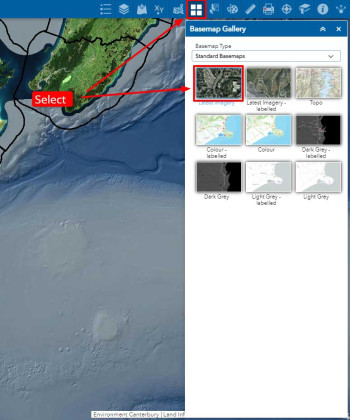
- If you like to add satellite imagery to your map, select 'basemap gallery' and then 'latest imagery'.
- Some of the asset lines and labels are only visible between certain scales. Zoom in and out to make sure you can see all the lines.
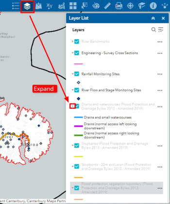
- You can view the legend for each layer by selecting 'layer list' and then clicking the small triangle next to each heading.
You can click on the coloured markings on the map to bring up a small label and description of the highlighted asset.
Where possible we have shown whether we normally access small watercourses/drains from the right or left. Maintaining access to the stated side is of most importance.
If you have any trouble using Canterbury Maps, you can phone our customer services on 0800 324 636 for help.
Gaining authority to undertake work in, on, under, through or near managed assets
The types of activities that are likely to require prior written authority include, but are not limited to:
- Widening, deepening and infilling any drain or small watercourse
- Altering, damaging or otherwise interfering with any drain or small watercourse, defences against water, flood protection vegetation, hydrological equipment and survey benchmarks
- Placing any material or structure in, on or near a drain or small watercourse or defence against water
- Connecting any pipe, channel or other flow conduit to a drain or small watercourse
- Allowing stock to damage drains or small watercourses, defences against water and flood protection vegetation
- Damaging or removing flood protection vegetation.
Please note this is intended guidance only. See the Bylaw for full details on what requires authority.
It’s important to consider other rules that may restrict the type of activity you can undertake in your selected watercourse. Certain activities may require a resource consent. If your project isn’t taking place on a watercourse managed by us, we encourage you to check with the appropriate Territorial Authority (local council).
Apply for a bylaw authority
We encourage you to get in touch with us prior to submitting your authority application. The best way to set up a time to chat is to email floodbylaw@ecan.govt.nz. We aim to respond within two working days of your inquiry.
The following information will help you when filling in your authority application form:
- Written approval needs to be provided from all owners and occupiers of the proposed site. If granted, the authority will be binding on every subsequent owner or occupier of that land unless it specifically states otherwise.
- A map or diagram of your proposed activity and the distances to any flood control or drainage assets and the extent of disturbance to these assets that’s being proposed.
- Any resource consent requirements under the Resource Management Act
- And regional plan provisions that apply (see regional plans for more information)
- Allow time for maintenance when proposing the length of your activity. Please note we prefer to issue authorities for a maximum duration of ten years. If you seek longer than this, please provide detailed information as to why.
- While the bylaw does not stipulate processing timeframes, we aim to respond to applications within five working days. If further information is required, this timeframe may be extended. We encourage you to get in touch with us prior to lodging your application.
- Approved authorities will record a reference number (FPB#), start and end date, a description of your proposed work, some conditions that must be adhered to and a plan/diagram of the activity. If your consent is acting as an authority, your FPB# will be recorded on your consent documentation to indicate that authority has been received.
- There is no cost involved when applying for an authority under the Flood Protection and Drainage Bylaw 2013. Environment Canterbury may, however, decide to prescribe a few for authorities in the future.
- If you wish to object the decision of your authority application, you can do so in writing, within 14 days of receiving the decision. The objection will be reviewed and considered by an Environment Canterbury representative independent to the original authority application reviewer.
Authority form for all activities (including planting)
Download planting guide (PDF file 1.39 MB)
| What we will look for | Expected conditions | What we aim to achieve |
|---|---|---|
|
Will your proposal restrict access to our assets for inspection and maintenance? Activity examples: Buildings, fences, hedges/planting, pump sheds, galleries |
Setback distances for fences, plantings or buildings. An alternative could be to provide alternative access or insert gates. |
Our machinery generally needs up to 7.5 metres for access to maintain our drains and small watercourses. If these waterways are not routinely maintained, they may create a flooding or erosion risk to your or your neighbour’s property. |
|
Will your proposal reduce the flow capacity? Activity examples: Bridges, culverts, drain realignment |
Limitation on the extent bridges and culverts can restrict the capacity of a waterway. For example, our preference would be for a single span bridge with a soffit higher than the adjacent banks. Requirement for structure to be maintained and free of debris. | To minimise any flooding on you or your neighbours' land. |
|
Will your proposal increase the risk of erosion and flooding? Activity examples: Flood protection, structures in the bed, drain realignment |
Restrictions on the extent of flood protection vegetation clearance, and/or replacement planting at the same or a neighbouring site. | Flood protection vegetation plays an important role in keeping a river in its channel by keeping berm areas stable and slowing floodwater. Our goal is to minimise the clearance of this vegetation and continually plant new areas. |
|
Will your proposal deflect flood flows in to the banks or onto someone else’s land? Activity examples: Bridges, culverts, drain realignment |
Restrictions to size, shape and location of structures in the bed of a river or diversion channels. The requirement to install erosion protection measures. | To maintain flow within the channel without scouring the banks and flooding neighbouring land. |
|
Will your proposal reduce the integrity of our stopbank network? Activity examples: Stormwater outlets, land development, truck crossings, tree planting. |
Restrictions to heavy machinery driving over stopbanks, depth requirements and agreed construction methodology and maintenance requirements | To maintain a strong and reliable stopbank network to contain floodwaters to an agreed standard. |
|
Do you want to undertake an activity in a floodway? Activity examples: Earthworks, fence installation, irrigation, storage dams |
Anything placed in a floodway should not restrict or deflect floodwaters out of the channel. Fences are not likely to cause a problem if they are well maintained. Dams and buildings might need to be located outside of a floodway. | To allow for the unimpeded passing of floodwaters so that floodwater is not deflected outside of the floodway. |
Applications for planting managed watercourses – Guidance
While planting is an important component of any waterway project and its management, the riparian/riverbank zone is closely related to the instream environment and can significantly impact aquatic habitat, land drainage, water conveyance and flood protection, which must remain the priority when carrying out any activity along a managed waterway.
The Flood Protection and Drainage Bylaw prevents landowners from putting in fences and other structures, and planting trees and other vegetation within 7.5 metres from the top of the bank of managed watercourses without written permission from Environment Canterbury.
When applying for authority to plant along managed watercourses, you must supply a planting plan. Your riparian planting plan assists you in identifying all the key components to consider before carrying out planting and provides us the right information to assess whether your proposed planting will impact on flood protection values along managed watercourses.
Download the planting template (PDF file 1.42KB)
What to plant and where
Below are key topics to guide you in completing a planting plan:
Limitations on where you can plant
To protect the integrity of, and ensure functionality of our flood protection assets, we require a minimum setback of five metres from the toe of stopbanks, culvert heads, floodgates/flapgates, and weirs. Providing for access to the watercourse could also limit planting locations. See the ‘Fencing/access’ section below for more information.
Plant species by planting zone
When selecting plant species, it is important to consider the growing environments within the different planting zones of a riparian margin and how the characteristics of plant species, once mature, could impact on the flood-carrying capacity of the watercourse within each zone. Planting should not damage the integrity and shape of the watercourse or cause/exacerbate erosion to the banks.
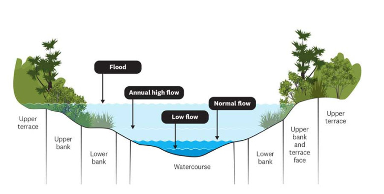
Planting zones and seasonal flows
When trying to identify planting zones, consideration should be given to the slope, distance from the stream, how damp the area is, how the stream flows throughout the year and areas that flood easily.
Planting zones include:
- Lower bank: this is the strip of land prone to flooding, where plants must be most tolerant of waterlogging. Use lower bank zone plants which are well-rooted and can survive many days underwater.
- Upper and terrace zones: this is on higher ground but may still be partially flooded every couple of years. Use upper bank zone plants, which tend to be trees and shrubs to provide shade and shelter.
Causing restrictions in the flow-carrying capacity or reducing the ability of the watercourse to pass flows can be a concern if riparian plantings are not well planned.
In order to minimise potential flooding issues, in general, we recommend:
Lower bank:
- Avoiding planting within 0.5 metres from the water’s edge; and
- Only native sedges that do not exceed one metre at full maturity (e.g., Carex secta) should be planted within two metres of the water’s edge.
Upper and terrace zones:
- Any flaxes/harakeke (Phormium spp.), toetoe and trees should be planted at least three metres from the water’s edge.
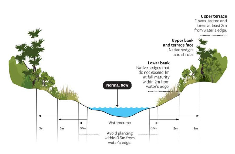
Planting setbacks
Fencing/access
Access to managed watercourses is required for maintenance purposes and, in many instances, requires machinery access. Vehicles to take into account for access include utes, tractors, draglines or excavators and spray trucks. It is critical to provide for continual, unimpeded access by machinery, when planning your planting locations and fencing, unless agreed otherwise in writing by the relevant Area Engineer or their nominee. We highly encourage contacting our team to assess access requirements specific to the watercourse you are proposing to plant.
Other things to consider when installing fencing are to ensure fences are sufficiently set back from the annual high flow height of the watercourse – this may be quite different from the low flow height. Allocating a one-metre grass strip around all fences to help filter out sediment, phosphorous and faecal bacteria from runoff and prevent plantings from tripping electric wires or being grazed is also advised.
Site preparation and maintenance post-planting
Site preparation is often required when establishing a new riparian planting area. Depending on site conditions, this could range from mechanically clearing weeds (by hand or machinery), to spot-spraying with agrichemicals.
To ensure the ongoing success of your riparian planting, maintenance is crucial. This could include (but not be limited to) weed removal, spot-spraying after plantings have established, and/or the replacement of dead plants. When completing your planting plan, please provide details of how you are going to maintain the planting site(s), as this is a key consideration when approving Bylaw applications.
Get in touch
For assistance in developing a planting plan and or advice on our managed waterways please email floodbylaw@ecan.govt.nz.
Any activity along managed waterways must not restrict the flow, shape, bank, or access to the river when fully grown.
Planting correctly protects water flow and flood protection assets. Not planting correctly can impede flood flows by reducing the channel size, trap debris, and be swept away with time and money wasted, and trap sediment and debris from floodwaters
Maintenance is the key – if you are planting trees in flood-prone areas you need to have the time and a plan to maintain them. Vegetative debris resulting from pruning, windthrow or windsnap must be removed from areas that flood.
Consenting
If your activity requires resource consent and also impacts our flood protection assets, the consent may be deemed an authority under the bylaw. The consent application process will assess if additional conditions need to be added to protect our assets under the bylaw.
If issued, the consent then becomes a deemed authority, with the consent and authority combined into one document.
Any resource consent expiring prior to 2 April 2013 for an activity covered by the bylaw is deemed to be an authority under the bylaw.
Any fully discretionary consent granted by us after 2 April 2013 is also deemed to be an authority (the ‘FPB#’ authority number will be recorded on the resource consent).
If your consent is not deemed an authority, you may require a bylaw authority as well as a resource consent.
You can contact us at floodbylaw@ecan.govt.nz if you have any questions about authorities as consents.
Get in touch
For assistance in developing a planting plan, any questions about authorities and consent and/or advice on our managed waterways, please email floodbylaw@ecan.govt.nz.
Further information
- Find out more about the consenting process.
- Search for your property.
- Apply for a bylaw authority.

