
New modelling gives clearer picture of sediment in Whakaraupō Lyttelton Harbour
A new scientific model shows where sediment in Whakaraupō Lyttelton Harbour comes from and where it settles, helping Whaka-Ora Healthy Harbour partners target restoration where it will make the biggest difference. The model also suggests sediment entering the harbour would need to be reduced by at least half in future to meet optimal national standards.
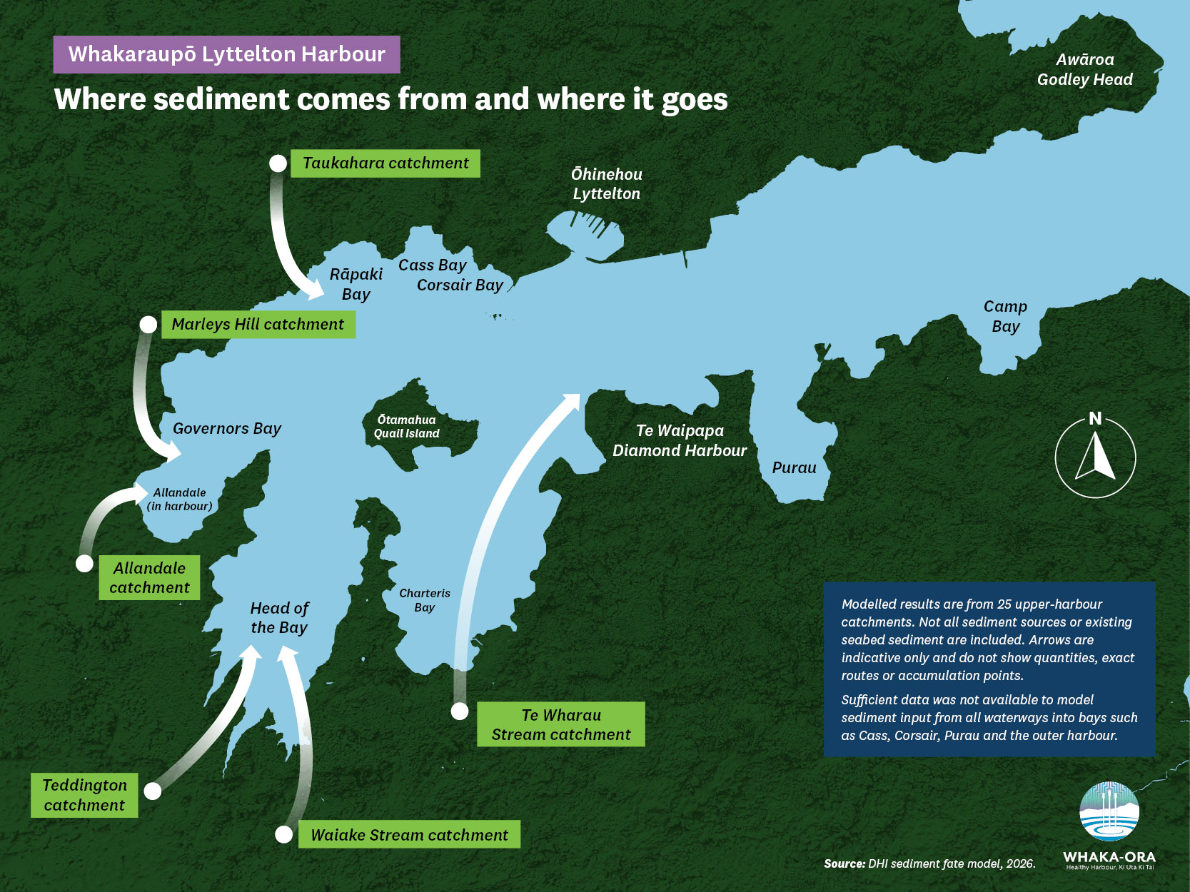
The model maps how soil and silt travels from 25 catchments that drain into Whakaraupō and identifies where sediment from each catchment settles, including bays, mudflats and coastal habitats. Catchments are areas of land where rainfall drains into streams and the harbour.
What the sediment model covers
By linking sediment sources on land to the places where it settles in the harbour, the modelling provides one of the clearest pictures yet of land-to-sea sediment pathways in Whakaraupō.
Sufficient data was not available to model sediment input from all waterways into bays such as Cass, Corsair, Purau and the outer harbour. Due to these limitations, the results will be used as a decision-support tool rather than a definitive account of every sediment source.
The model, and the accompanying findings, were developed by international water environment experts DHI Water and Environment Ltd. It was commissioned by Whaka-Ora Healthy Harbour partners – Te Rūnanga o Ngāi Tahu, Canterbury Regional Council (Environment Canterbury), Christchurch City Council, Lyttelton Port Company and Te Hapū o Ngāti Wheke.
Whaka-Ora Healthy Harbour’s vision is to ‘ensure the area’s ecological and cultural health as mahinga kai is restored for us and our children after us’.
Why sediment matters for harbour health
Whaka-Ora Healthy Harbour Programme Manager Sarah Wilson said sediment is known to be compromising the health of the harbour, for example by burying cockle beds in layers of silt. What was missing was a more detailed understanding of where that sediment comes from and how it moves through the harbour.
"This modelling gives us a much clearer picture of how sediment moves through Whakaraupō, and where there are opportunities to make the biggest difference” Sarah said.
"A healthy harbour supports cultural values, biodiversity, recreation and community wellbeing. Ultimately, this work is about protecting and restoring those values for future generations."
Where sediment builds up in the harbour
The modelling identified patterns in both where sediment comes from and where it accumulates.
It also estimated how much sediment input would need to be reduced for harbour sedimentation rates to reach levels associated with healthy harbour and estuarine ecosystems.
It showed sediment builds up mostly in the sheltered upper harbour, with the highest rates of accumulation in:
- parts of Head of the Bay
- Charteris Bay
- Governors Bay.
Much of the central and outer harbour receives comparatively less sediment from the upper harbour catchments.
Modelled sediment pathways in Whakaraupō Lyttelton Harbour
How much sediment inputs may need to fall
To meet levels associated with healthy harbours, sediment inputs would need to reduce across the harbour by at least half.
“We’ve known for some time that sediment is affecting the health of the harbour. What this model gives us for the first time is a clearer sense of the scale of the challenge ahead, including the level of reduction needed,” Sarah said.
A handful of catchments have an outsized influence on harbour sediment, according to the model. Te Wharau Stream is the largest modelled sediment source, affecting Charteris Bay and parts of the wider harbour. Waiake Stream and Teddington were identified as major contributors to sediment accumulation in Head of the Bay.
Modelling also showed sediment can travel well beyond the bay where it enters the harbour. Sediment from Te Wharau Stream, for example, was modelled reaching Godley Head.
The work was commissioned as part of the Whaka-Ora Healthy Harbour programme and drew on catchment, harbour and environmental monitoring data, as well as previous research undertaken in Whakaraupō. This included previous Whaka-Ora Healthy Harbour-funded research by the University of Canterbury on erosion and sediment accumulation in the upper harbour. The model was tested against observed sediment plumes, sediment cores (which measure long term sedimentation) and harbour monitoring information, such as mud content.
How the findings will guide restoration
The findings will now be considered alongside other research and restoration work underway across Whakaraupō. One example is a Whaka-Ora Healthy Harbour-funded study on erosion hot spots that will provide a map of where specific restoration measures can help control erosion in the landscape and sediment reaching the harbour. This study is led by the University of Canterbury.
Key findings from the sediment modelling
- The modelling assessed sediment from 25 catchments around Whakaraupō. (It does not include all sediment sources or sediment already on the seabed).
- Sediment accumulation is highest in sheltered upper harbour areas including Head of the Bay, Charteris Bay and Governors Bay.
- Te Wharau Stream and Waiake Stream are among the harbour's most influential sediment sources.
- Some smaller catchments have strong local effects, namely Allandale, Marleys Hill and Taukahara.
- Sediment travels well beyond where it enters the harbour, particularly from Te Wharau Stream catchment.
- Sediment reductions of at least 50% would be needed to achieve healthy thresholds in most affected areas.
These key findings have been shared with the Whakaraupō Lyttelton Harbour community at a research presentation and workshop hui. Once community feedback has been considered, the full report will be published on the Whaka-Ora Healthy Harbour website.