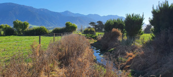
Waterways in Kaikōura
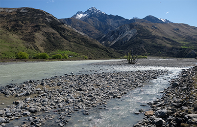
Waiau Toa Clarence River in northern Kaikōura - Image courtesy of Heath Melville.
The Kaikōura Zone has many short, steep, hill-fed rivers, with the upper reaches of all waterways in the zone having the best water quality. The lower catchments are more often affected by their surrounding land use (both urban and rural) and have poorer water quality.
Local rivers such as Oaro, Kahutara, Kōwhai, Hāpuku, Puhi Puhi and Kēkerengū are not large and often carry little water during the dry summer months. However, when fed by southerly rain they quickly rise and flood, carrying a great deal of sediment downstream.
There are many smaller creeks such as Te Kāretu / Blue Duck Creek and Omihi Stream, and other lowland, spring-fed streams, such as Harnetts Creek, Waikōau / Lyell Creek, and Middle Creek.
See information about some of the major waterways/freshwater sites in Kaikōura:
Lyell Creek/Waikōau
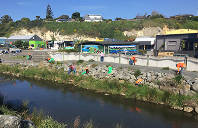
Love the Lyell community group run clean up days, with local schools, businesses and community members getting involved.
Lyell Creek/Waikōau flows from spring heads below the mountains, through the Kaikōura Flats and central business area, then out to sea.
It has important mahinga kai, and wider cultural, recreational and visual amenity values that need protection and enhancement.
About 150 properties lie on the banks of the Waikōau and have the potential to impact its water quality.
Watch this video of the creek mouth being opened.
History
Te Wai o Matamata is a former lagoon located at the mouth of the Waikōau named after a taniwha that used to dwell there.
The Kaikōura Flats, which are drained by the Waikōau, were developed for agriculture when the first European settlers came into the area during the 1850s.
These people drained the existing wetlands and milled the harakeke/flax in the area to make way for sheep grazing and the production of potatoes, wheat and milk.
Farming and urban activities including sewerage and factory waste were historically a major source of pollution in the stream.
In 2012, the Kaikōura Water Zone Committee made cleaning up Waikōau a priority. With commitment from local community groups, schools, staff, businesses and organisations, the stream has seen great improvements in recent years. Read more about the history of Waikōau (PDF file, 1.53 MB).
Water quality
We maintain sampling sites throughout Canterbury as part of the long-term monitoring programme on the state of the environment in the region, which includes Waikōau. View river flow data for Waikōau/Lyell creek.
We have also worked with Kaikōura District Council and the Love the Lyell Governance Group to design and secure a stormwater filtering system for the waterway, with an aim to help reduce contaminants from urban run-off sites and improve water quality.
2016 Earthquakes
The Kaikōura Plains Recovery Project, an MPI Earthquake Recovery funded project, commissioned two reports by NIWA to identify issues and recommendations for recovery in the Lyell Creek catchment post 2016 earthquakes. These recommendations are being used by staff.
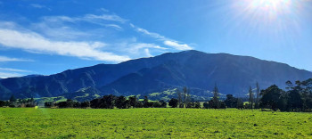
Waiau Toa Clarence River
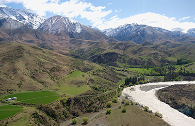
Waiau Toa Clarence River with its amazing scenery - Image courtesy of Heath Melville.
The Waiau Toa catchment area is around 3,200km² and at more than 200km long, it is one of the longest and most remote rivers in New Zealand, with some of the best scenery in the world.
It has a high cultural value for Ngāti Kurī, with a whakapapa status as the parent of many other rivers in the region. Any impact on Waiau Toa has an impact on the rivers that are linked to it through whakapapa, as well as iwi who are whakapapa to the river.
It embodies ki uta ki tai (from the mountains to the sea) (PDF file, 4.2MB), and like all our waterways, it is essential to protect this wonderful river.
Ongoing work to protect natural area
Numerous projects are ongoing in the catchment, focusing on weed and predator control, braided river bird habitat protection and landowner/community engagement. These projects have support from a range of other organisations.
Weed and predator control project
This project started in 2016 and has focused on long-term weed control to protect the braided river character and biodiversity values, with regard for more than 100 at risk and threatened flora and fauna in the wider Waiau Toa environment.
Braided river bird protection project
Another project, in the upper catchment, has focused on pest control and habitat protection for our endemic black-fronted terns. This project started in 2015.
The protection and enhancement of mahinga kai values, indigenous biodiversity habitat and species, and ki uta ki tai (from the mountains to the sea) have all been drivers for projects in the catchment. Waiau Toa is also one of the Kaikōura Water Zone Committee's priorities.
Lake Rotorua
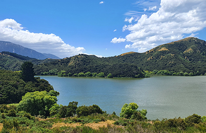
Lake Rotorua has significant cultural values, with waterfowl and eel being the main foods gathered in this area.
Situated a short distance from Peketa, Lake Rotorua and the smaller Lake Rotoiti are lowland lakes. A QEⅡ covenant protects Lake Rotoiti which has been fenced and planted, with a weed control plan in place.
The larger Lake Rotorua is managed by local farmers who have reduced the land use effects on the lake and are undertaking a weed control programme on the hills and banks surrounding the lake.
Water quality
Lake Rotorua is around 45 hectares and was formed from the build-up of gravels deposited by the nearby Kahutara River. The water quality of the lake has been affected by the number of waterfowl present in the area, plus the surrounding land use.
Bird life
Lake Rotorua is a wildlife reserve that is home to a substantial number and diversity of native birds such as riroriro (grey warbler), toutouwai (robin), pīpipi (brown creeper), pīwakawaka (fantail), korimako (bellbird) as well as tītitipounamu (riflemen).
Native waterfowl that reside in the lake and its surrounding area include kāruhiruhi (pied shags), kuruwhengi (shoveller ducks), tētē (grey teal), kawau (black shags), pūtangitangi (paradise shelducks) and the rare pūteketeke (crested grebe).
It is also home to a number of exotic bird species such as mallard ducks and Canadian geese.
Cultural values
Lake Rotorua was used as a mahinga kai site by Ngāi Tahu as well as the earlier tribes such as Ngāti Tūmatakōkiri and Ngāti Wairaki. The main foods taken from this area were waterfowl and tuna/eel.
Tūpuna/ancestors of the area had considerable knowledge of places for gathering kai and other taonga, and ways in which to use the resources of the lake, the relationship of people with the lake and their dependence on it, and tikanga for the proper and sustainable utilisation of resources. All of these values remain important to Ngāi Tahu today.
Middle Creek/Te Wai-o-pātiki
Middle Creek/Te Wai-o-pātiki catchment project to protect and enhance waterway
Middle Creek/Te Wai-o-pātiki catchment hosts a mixture of dairy farms, dry farms, and lifestyle blocks.
Key factors identified over the course of a survey included critical sources of contaminants such as overland flow paths, bank slumping, stock access, spring heads, discharge sites, and crossing points, as well as physical attributes such as aquatic plants, riparian coverage, pest plants, fish barriers and blockages.
This three-year project to boost biodiversity and improve water quality in the Kaikōura Flats’ Middle Creek/Te Wai-o-pātiki catchment began late last year and will be completed in 2024.
Mill Road Catchment Project
The Mill Road catchment hosts a mixture of lifestyle and grazing properties.
The Mill Road catchment hosts a mixture of lifestyle and grazing properties.
The catchment project was established after opportunities along Mill Road were identified that could benefit water quality and enhance biodiversity in the catchment.
Key ways we are assisting landowners include helping co-ordinate action, supplying locally sourced native plants suitable for the area, and sharing information and resources with them including about mahinga kai protection. We are also helping landowners measure the success of their individual projects through methods like electric fishing.
Read the project newsletter and final report:
River flow monitoring
We record water levels at 155 river and lake sites in Canterbury. We measure river flow at 132 of these sites and this information is combined with water level data to produce continuous flow records.
We report this alongside data from 19 other sites recorded by partner agencies such as the National Institute of Water and Atmospheric Research and Christchurch City Council.
See river flow data for all of Canterbury.
See river flow data for Kaikōura sites: