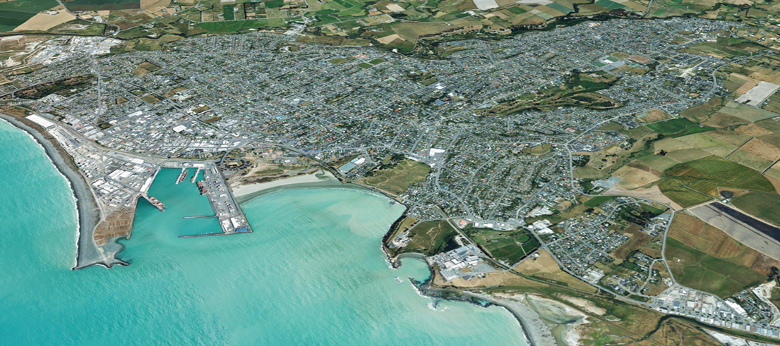
New aerial photography of our region
New aerial photography of the Ashburton, Banks Peninsula, Mackenzie and Timaru districts has been captured by Canterbury local authorities and Environment Canterbury, as part of a collection that dates back 100 years.
Each summer the 11 Canterbury councils, together with a public-private partnership, capture a different area of the region, over what is now a decade-long programme. Thousands of individual photographs are then combined to provide a continuous surface all across Canterbury.
The digital photographs are captured using a specialist high powered camera on board an aircraft flying at an altitude of 1400m, during optimum weather conditions to minimise shadowing. Images are then processed to ensure correct geographic location and overlapping, and then terrain is flattened in a procedure called 'orthorectification'.
The imagery is hosted on the Canterbury Maps website, and the collection also contains historical digitally-converted film photographs dating back to the 1920s.
How to view the new photography
You can view the aerial photographs in 2D and 3D in Canterbury Maps property search, or 2D with other spatial information in Canterbury Maps viewer - best experienced via a tablet or desktop computer. Use the search bar on these sites to type in the address or location of interest.
You can also use our swipe tool to see before and after photography. Here's a short video on using the swipe tool, and you can see this in action in the dropdown below.
New areas captured
- Ashburton District: Ashburton, Chertsey, Hakatere, Hinds, Lake Clearwater, Lauriston, Mayfield, Methven, Mt Somers, Rakaia, Rangitata Huts.
- Banks Peninsula: Okains Bay, Little Akaloa, Little River, Cooptown, Le Bons Bay, Koukourarata Marae, Birdlings Flat, Pidgeon Bay, Kukupa, Barrys Bay, Duvauchelle, Robinsons Bay, French Farm, Tikao Bay, Takamatua Bay, Akaroa, Wainui and Anchorage Bay.
- Mackenzie: Tekapo, Albury, Burkes Pass, Fairlie, Kimbell, Twizel, Manuka Terrace, Cemeteries.
- Timaru District: Timaru (shown above), Pareora, Peel forest, Pleasant Point, Temuka, Geraldine.
Aerial images can be particularly useful when searching for information on a property if you're in the market to buy.
For councils, having access to historical and up to date collections of aerial photography, provides visual context when working with location datasets, to enable decision making. For instance, the imagery allows the measurement of distances against natural features like river banks, coastline, urban area roads and footpaths, electrical poles and pylons and so forth.

New imagery captured of Hakatere / Ashburton River
We use the photography, and work with large amounts of location information, for a variety of functions, including:
- monitoring land use
- traffic management
- managing public and private utility networks
- property information and developing farm environment plans.
Regionally, it is used as part of our processes in:
- hazard identification
- coastal erosion
- climate change monitoring
- river engineering, including flood control
- biosecurity
- environmental monitoring
- disaster records, showing before and after status
- regional policy and planning
- considering resource consents applications, such as land use consents, coastal permits, water permits, discharge permits
- planning public passenger transport.
The Canterbury Maps website provides free access to maps, records, information and data from local councils in the Canterbury region, such as:
- Air and water quality, recreation and parks, planning zones, resource consents, transport links, local attractions and council services.
- Historical records, plans and aerial imagery.
- Regional plans and management information.
The interactive maps on the site provide many easy-to-use ways to look at and find information held by the councils. You don't need a special licence, subscription or software to use them, simply access the maps viewer on your computer or hand-held device. You'll find more information on what can be done with these maps, in our guides and videos.


