Improved resilience for river flow monitoring systems
The May 2021 Canterbury flood was classified as a ‘one in 200-year' event, with some of the highest river flows we have ever recorded.
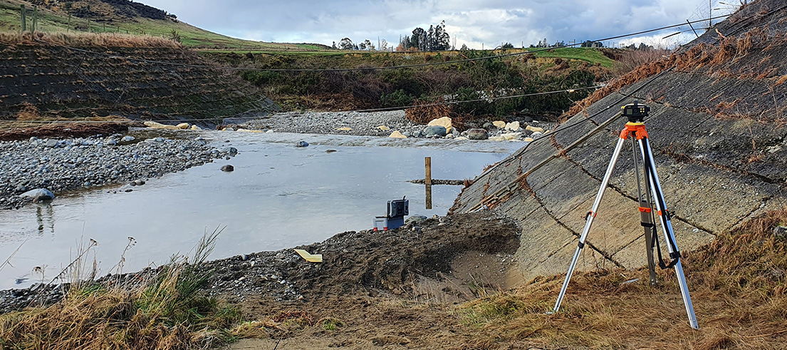
It resulted in significant loss and damage to our network of water level monitoring equipment across the region. We are now in the process of upgrading this network across the region, thanks to central government’s climate resilience fund and local funding.
We record water levels, flow rates and rainfall data at rivers and lakes in Canterbury through a network of 152 water level recorders and 87 rain gauges. One of the largest networks of its kind in the country, it enables us to monitor and report on these environments. We also make information available to the public, such as the rainfall and river flow data on our website. There are two teams servicing the network across the region, headed by Radford Gulliver and Anthony DeJoux.
Extreme rain damaged our hydrometric network
In the May 2021 flood, our rain gauge in Mt Somers recorded its largest 48-hour rainfall ever, at 526mm. Further east at State Highway 1, this was the biggest flood on record for the Ashburton River/Hakatere.
Our hydrometric network – the network of gauges, recorders and other technology we use to monitor water levels, flows and rainfall – was significantly damaged, with 19 flow recorders lost or destroyed.
"These flows were in some cases the highest we have ever recorded and our network wasn’t up to handling this," Anthony DeJoux, Science Field Team Leader Southern Region – Hydrology said.

Using radar gauging at peak flow, which measures surface velocity and enables us to calculate the flow.
"Most of these recorders were washed away due to significant riverbank damage, while others were simply inundated with water."
We had to quickly get the network up and running again and the first two months after the flooding event were spent carrying out urgent remedial works, in case of additional flooding.
"The initial response was easily $200,000 worth of work to get us back up and running however, we recognised the importance of not rushing into permanent repairs.
"We wanted to develop a strategy that would enable us to make the network better and stronger."
Upgrading the system
Making the network better and stronger wasn’t just about simply upgrading the system ‘like for like’.
The upgrades are being done in a way that will not only enable the equipment to withstand a ‘one in 200-year' event, but they will also safeguard the system if damage does occur from extreme weather events or infrastructural damage resulting from the likes of earthquakes.
We use a telemetry system, which is the automatic measurement and transmission of data from our monitoring sites. The way this data is delivered back to us – which is a critical part of the system – can be through satellite, radio or General Packet Radio Service (GPRS).

The yellow boat uses a type of sonar technology to measure the river flow
A big part of the upgrades has been ensuring these systems can use two types of data transmission so if, for example, the cellular networks become overloaded in a flood event, we can access the data through satellite or radio instead.
Previously, some sites, such as the Kowhai River in Kaikōura only had one water level recorder and one rain gauge, putting it at risk. We are using dual sensors and recorders, sometimes using multiple sites within a catchment and using external cellular and satellite providers where possible to safeguard communications avenues.
"We are building resiliency and redundancy into the network,” Anthony said.
"It’s about not putting all your eggs in one basket so we can maintain our monitoring capabilities in the case of extreme events."
We have identified more than 30 locations across the network which would benefit from being upgraded to a ‘one in 200-year' event. Five of these upgrades have now been completed.
"Resourcing has been our biggest hurdle, particularly as we were hit by later rainfall events, including further damage from the July 2022 floods in Omarama," Anthony said.
Funding for climate change-induced weather
Climate change-induced events across the country have highlighted the urgent need to continue investing in flood protection infrastructure, including works such as the upgrading of our water level monitoring equipment.
Co-investing with central government means being able to continue with important flood protection and related works such as the upgrade to our water level monitoring network, projects that would have otherwise taken decades to fund through the current rating districts and undertake works to protect communities from changes that we know are coming, benefiting communities both now and for the future.
Read the call from Te Uru Kahika to Central Government for long-term co-investment.