Co-investment critical to the future of flood protection
Acting general manager of operations Leigh Griffiths, shares her thoughts on the future of flood protection in Waitaha Canterbury.
Climate change continues to increase the risk we face when it comes to flooding, and maintaining and improving flood protection is increasingly expensive and complex.
Over the past three years, significant extra investment has been made within our river corridors. This has been enabled through the Ministry of Business Innovation and Employment’s Kānoa – Regional Economic Development & Investment Unit and rates for two major projects:
- Climate Resilience Funding (Covid-19) Shovel Ready projects – this one-off funding has enabled fast-tracking of river works projects throughout the region such as infrastructure upgrades, planting, pest species clearance and fish passage improvements. The work is scheduled to be completed in December 2023 at a total cost of $24.2 million.
- 2021 Flood Recovery - this work is in response to the large flood experienced in central and south Canterbury in May 2021. The work involves repair and replacement of damaged flood protection infrastructure from this event. This work is scheduled for substantial completion by June 2024 at a total cost of $22 million.
Co-investment enables us to deliver works faster and more efficiently than rates alone can afford and we are thankful to receive one-off funding like this, but it doesn’t go far enough to support longer term conversations about things such as managed retreat or giving rivers more room to move.

Leigh Griffiths
Many times, it only covers repair of existing infrastructure to the same level of design as it was prior to flooding, which means we’re unable to afford enhancement works or significant changes to the design.
As we feel the effects of climate change, our flood protection measures will be challenged. We need to prepare now for these events by looking at rivers with a holistic, systems and intergenerational viewpoint to value, protect and restore them now and into the future.
Changing expectations for flood protection
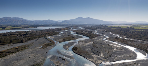
River management has many tools in the box, one of which is giving the river more room to move. There’s no one size fits all when it comes to flood protection and Canterbury’s braided rivers with their wide riverbeds and massive variation in flow, add extra complexity to these issues. Alongside mana whenua and the community, we must consider things such as the river's proximity to urban environments, existing/historical biodiversity and mahinga kai values, climate change impacts, funding availability and more.
Flood protection is carried out through 58 river control and drainage schemes from Kaikōura to Waitaki. Flood protection assets value is $850 million region-wide.
Those within a river rating scheme pay a targeted annual rate to fund the flood protection provided to them. The more benefit they get from the flood protection infrastructure, the more rates they pay.
Community, mana whenua and central government expectations are changing when it comes to flood protection and climate change resilience. We are responsible for managing flood protection, land drainage and erosion control works across the region, we must pivot to meet those expectations while continuing to keep people safe from flooding and protecting the environment.
While in some cases, built infrastructure such as stopbanks remain the primary tool in the toolbox for keeping people safe from flooding, we have been introducing other initiatives for a number of years. Some of these include:
- Braided River Revival Whakahaumanu Ngā Awa ā Pākihi (BRR) – this programme was established through the Long-Term Plan in 2018 and focuses on working collaboratively to maintain and enhance the natural character of braided rivers. It’s about aligning all our work in rivers, forming alliances with mana whenua, agencies, and the community to take a holistic approach to river management. BRR signals a shift from river management focused solely on flood protection, to one that also facilitates collaborative efforts to protect and enhance the range of values that make our braided rivers unique and important ecosystems.
- Regionwide Berm Transition Project – which uses natural infrastructure (such as planting and weed control) to increase the flood resilience of river berms and support the regeneration of native plant habitat. This project was made possible thanks to one-off funding from the Ministry of Business Innovation and Employment’s Kānoa – Regional Economic Development & Investment Unit. Most of this work will be finished by December 2023 and continuing the work the get the most benefit will require ongoing funding.
- Infrastructure design changes – following the 2021 flooding we modified some designs solutions during our recovery work, rather than simply replacing the flood protection infrastructure that was in place. For example, we modified the repair work that was required to a section of stopbank along the Ōpihi River by building the stopbank further back from the river to extend the berm and give the river more room to move.
Deterioration of Canterbury's braided rivers
Canterbury’s braided rivers are iconic and ecologically critical corridors that have deteriorated over time. Losses in water quality and biodiversity have resulted from human-induced pressures including encroachment, land use change, water abstraction, climate change, invasive plants and animals, and pollution.
Historically, settlements were established alongside rivers to utilise the resources they provide. While this has enabled intensive use of fertile land, economic development, and access to food, water and recreation, it also comes with risks which have traditionally been addressed by flood protection. As we experience more frequent and severe weather events causing damage to our flood protection infrastructure, the community’s ability to continue funding this work is challenging.

Floodwater flowing through Kaikōura township - September 1954
Riverbed management
Rivers have many functions. They carry millions of tonnes of sediment, are home to natural habitat, are teeming with biodiversity and provide mahinga kai and recreational values for those who connect with them.
Historical imagery shows a reduction in open gravel area and general increase in weeds on previously active riverbeds across the region meaning they require active intervention to manage food risk. Weeds tend to slow flood flows, raise water levels, encourage deposition of sediment, and potentially force floodwaters around obstructions.
Flooding does a good job of flushing sediment out of river systems but as the flow is reduced, particularly in larger braided river systems, the sustained flow that historically carried sediment and gravel out to sea even when not in flood, has reduced.
In some rivers across the region there is a gravel aggradation issue and in some places the bed is building up. We encourage gravel extraction in those areas as much as we can.
Gravel extraction generally compliments other flood protection measures such as maintaining vegetated buffers, construction of flood protection works (such as stopbanks and rock erosion control), land use planning and emergency preparedness. Flood protection schemes are designed and maintained to certain levels of flood flow and there will be flood events that exceed those capacities. In these instances, we expect that out of river flooding may occur.
Community input
Ensuring those who live alongside rivers have a say in developing solutions for flood protection is critical to the work we do. We must also balance the ability of the community to pay and ensure continued protection while any change is investigated and implemented.
We are currently reviewing the regional planning framework for Canterbury. This process seeks to align our planning framework with national direction such as the National Policy Statement for Freshwater Management 2020 (NPS-FM), including Te Mana o te Wai.
This includes the current ‘Our Future, Canterbury’ campaign, which is gathering community views on what we should prioritise. It will inform the 2024 Long-Term Plan and then the drafting of our Regional Policy Statement.