River projects
We’re delivering large-scale river and flood management projects to help vulnerable areas across Waitaha Canterbury become more resilient to the impacts of climate change. These projects are designed to better protect communities, infrastructure, and the environment.
Varying in size, scope, and funding, our initiatives aim to reduce flood risk and improve long-term river resilience. Co-investment from central government enables us to fast-track critical work—creating an intergenerational legacy that would otherwise take decades to achieve under current local funding models.
By accelerating these projects now, we can better prepare our region for the changes we know are coming.
Ongoing river projects
Find a list of our ongoing projects, including new and upgraded flood protection infrastructure, climate adaptation efforts, and renewal of critical assets.
Regional Infrastructure Fund (RIF) Flood Resilience Programme
With more than 78,000 km of rivers and streams, Waitaha Canterbury is no stranger to severe flooding, highlighting the need for robust flood management infrastructure like stopbanks, floodgates, and weirs.
Improving this infrastructure increases our flood resilience, meaning we can better protect homes, businesses, productive land and critical infrastructure like roads, railways, and medical centres.
The Regional Infrastructure Fund (RIF), administered by Kānoa – Regional Economic Development & Investment Unit, co-invests in projects that improve resilience to natural hazards. Funding is split 60∶40 between central government and our community (via Regional Council rates), enabling councils to deliver flood protection much sooner and reduce the costs and impacts of flooding to our communities.
Projects funded under tranche 1:
Announced in Budget 2024, RIF tranche 1 provided $9.5 million in total project funding to accelerate three flood resilience programmes. These projects are being delivered now.
Last updated February 2026.
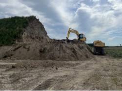
Rangitata flood and resilience work #2

Rangitata River during 2019 flooding
We’re continuing and expanding our successful programme of work on the Rangitata River.
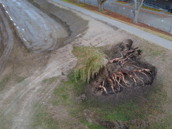
This project will improve flood resilience across the catchment by clearing vegetation and building three new stopbanks to help contain flows to the South Branch during floods.
The consent for the stopbanks has been granted and the construction contract has been awarded. Work started in early May and will continue through to June 2026.
Further vegetation clearance is planned around the Arundel Bridge, and we are finalising the scope of this work.
Stopbank construction underway on the Rangitata
Earthworks progressing on the Rangitata flood protection scheme
Construction crews building new flood protection infrastructure
Structure upgrades/adaptation programme
This programme is aimed at the adaptation of critical and aged flood protection infrastructure (culverts, weirs, floodgates, stopbanks, tree edge reinstatement, rock work and erosion control fencing) and consists of several workstreams across the region.
The projects we're working on include:
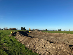
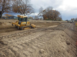
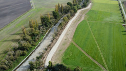
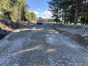
Ōrari River stopbank upgrade
The contract for the stopbank upgrade (between SH1 and the KiwiRail bridge) was awarded in March. Construction started and will continue through to the end of May 2026.
Further tree removal will be scoped along the stopbanks upstream of Burdon Road. We aim to start this work before the end of May.
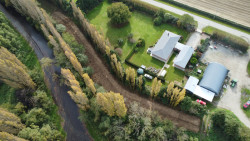
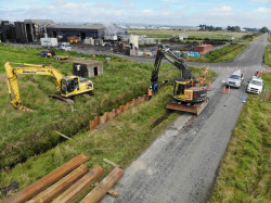
Kaiapoi River stopbank upgrade
Detailed design has been finalised and the contract awarded for the stopbank upgrade at the Murphy Park end. Construction started in May and will continue through to June 2026. We are finalising detailed design for the Mandeville Bridge end and aim to start procurement in spring 2026.
Tree removal from the stopbank at Murphy Park
Bulldozer reshaping the Kaiapoi River stopbank at Murphy Park
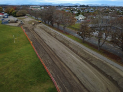
Aerial view of stopbank upgrade works in progress
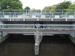
Kaiapoi River floodgate upgrade (Lineside Road)
This project involved upgrading a floodgate including thorough cleaning, resealing/repainting, and replacing some bearings to ensure resilience of the structure and that it works as expected in a flood. Work on this project is complete.
Ruataniwha Cam River floodgate upgrade
Final work on the project has been completed, including tree stump removal, bank reinstatement, water blasting, resealing, painting, and reinstating the cycle/walkway.
The existing Cam River floodgates before refurbishments
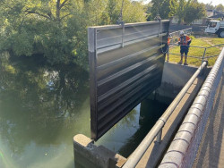
Installation of temporary sheet pile to de-water the floodgate
The Cam River Floodgates after refurbishments
Ruataniwha Cam River stopbank upgrade and tree removal
This project includes removing trees and upgrading the stopbanks above State Highway 1 on the Cam River to provide the agreed level of flood protection for the community.
Trees have been removed and the stopbank has been upgraded, the work is now complete.

Cam River stopbank before work

Cam River stopbank after work
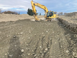
Lower Hinds stopbank upgrade
Construction work, including tree removal and stopbank upgrades along two sections, started in early March 2026 and was completed in mid-May. We will now carry out further investigations for the remaining upgrades and aim to complete this work in summer 2026–27.
Works in progress to upgrade stopbanks on the Lower Hinds River
Aerial view of completed stopbank upgrade on the Lower Hinds River
Aeiral view of completed stopbank upgrades protecting nearby properties
Ruataniwha Cam River stopbank upgrade and tree removal
All work to remove trees and upgrade stopbanks above State Highway 1 on the Cam River is now complete. These upgrades provide the agreed level of flood protection for the community.
Kaiapoi River floodgate upgrade (Lineside Road)
The works are now complete and included:
- repainting of steel mounting frames and gates (and fitting of new seals)
- replacement of all gate bearings
- removal of sediment/spoil from culverts
- repairs to concrete damage
- installation of new access ladder, lifting ropes, pulleys and staff gauges to improve safety around the structure.
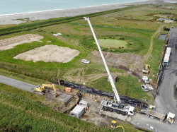
Waitarakao/Washdyke/Seadown works

Waitarakao tree removal works along new stopbank and drain alignment, before (above) and after (below)
This project helps prepare for climate change by moving the existing drain and coastal stopbank between Waitarakao Washdyke Lagoon and Beach Road in the Seadown Drain scheme.
Work to install the new culvert at Aorangi Road was completed in March 2026. The consent application for the stopbank and drain realignment has been lodged. Engagement with stakeholders, interested parties and rūnanga partners is continuing through the consenting process. We aim to start procurement for the stopbank and drain construction in September 2026.
Learn more about the Waitarakao lagoon
Waitarakao flood protection works in progress to remove large bund
Sheet piling underway for the new Waitarakao culvert
Culvert installation works underway at Waitarakao
Projects funded under tranche 2:
In October 2025, the Government announced a further $21.5M of RIF co-funding (RIF tranche 2) to accelerate nine key projects, with work scheduled to start in summer 2025/26.
Flood warning (telemetry) upgrades
Project description: This project will upgrade and expand flood warning systems (telemetry) to provide reliable, real-time data. The goal is to improve forecasting and reduce the impacts of severe weather before, during, and after flood events.
Structure upgrades/adaptation programme
Project description: This project extends the work done under tranche 1 to adapt critical and aged flood protection infrastructure (including stopbanks, culverts, weirs, and floodgates) and consists of several workstreams across Waitaha, including:
- investigations
- monitoring
- capital upgrades.
Works completed to date:
Culvert installation – Ashburton River North Branch
This work involves installing a culvert through the stopbank on the true right of the Ashburton River / Hakatere north branch. The culvert will allow breakout floodwater trapped behind the stopbank to return to the river during flood events.
Work will start by the end of May, and we aim to finish by mid-June.
Bank rebattering – Halswell
This work involves reshaping the banks of the Halswell River channel to a more stable slope to reduce erosion and improve flow capacity.
Work was carried out at two locations along the Halswell River. The larger bank repair was completed on 28 April, and the smaller bank repair was completed in early May.
Channel condition improvements – Dry Creek&
This workstream involves upgrading channels in Dry Creek and three tributaries. The upgrades include gravel extraction, installing grade control structures, and reshaping channel banks and beds. These improvements will increase flood resilience and help protect nearby roads and properties.
The work completed so far includes the removal of gravel and the construction of grade control structures to help reduce erosion of a crossing point at one of the tributaries. The contractor then moved on to the main Dry Creek channel to remove aggraded (built up) gravel from the bed and reshape the banks. We aim to have these works finished by the end of May.
Taranaki Creek Floodgate – Ashley River
This work involves repairing a floodgate at Taranaki Creek, off the Ashley River. The upgrade includes replacing the weed screen, winch and mounts, and making safety improvements to improve the resilience of the structure.
A new weed grille is being fabricated by a local engineering company and will replace the existing structure, which has reached the end of its service life. A new wire rope pulley system will also be installed to improve operation and reliability.
Fabrication is expected to be completed by the end of June, with installation planned for July.
Kaikōura flood and river resilience
Project description: This project upgrades flood infrastructure around Kaikōura, including scour protection, berm strengthening, vegetation clearance, and improvements to the township floodwall. These upgrades will better protect homes, businesses, farms, and key transport routes like roads and rail.
Works completed to date: The works to supply 4000 tonnes of rock started in March. Rock has continually been transported from the quarry to the stockpile location and will continue throughout the year. A total of 2000 tonnes is expected to be transported and available at the stockpile by the end of June 2026.
Procurement for the removal of wattle trees from the Kowhai River channel and berms was completed in early May. The contractor will start work on 1 July 2026. Additional tree removal work will be scoped and started later in 2026.
Rakahuri Ashley flood and river resilience
Project description: This project upgrades stopbanks and strengthens berms around Kaiapoi and Rangiora to boost flood resilience. These upgrades will better protect homes, businesses, farms, hospitals, schools, and key transport routes including roads, rail, and the state highway network.
Works completed to date: Phase 1 works included clearing compromised trees from the berm upstream of the SH1 bridge and removing dead standing trees and overgrown vegetation, including willows, from the fairway near the confluence of the Ōkuku River.
Work started in early March and was completed in early May. The next phase of tree clearance is planned for summer.
Waimakariri flood and river resilience
Project description: This project upgrades flood protection infrastructure across the Waimakariri-Eyre-Cust scheme, including stopbanks, floodgates, and culverts. It also involves tree clearance and berm strengthening to improve flow capacity. These works will provide stronger flood protection for Christchurch City, Kaiapoi, and surrounding critical infrastructure such as roads and rail.
Works completed to date: Procurement for the floodgate upgrade and repair at Courtenay Stream (a tributary of the Waimakariri River) was completed in February 2026, and work started in early March.
The contractor has established a temporary stream diversion to allow the floodgate to be dewatered while maintaining water flow. Once dewatered, the existing floodgate will be removed to make way for a new prefabricated concrete structure.
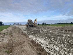
Hakatere Ashburton flood and river resilience
Project description: This project upgrades flood protection for the Ashburton Hakatere river scheme and Ashburton-Hinds drainage scheme. Work includes stopbank upgrades, gravel extraction for community stockpiles, berm strengthening, erosion control, and improvements to flood protection structures. These upgrades will better protect homes, farms, businesses, schools, hospitals, and key transport routes.
Works completed to date: Weed and vegetation clearance started at Lake Hood in April and at Croys Road in early May, with work completed in mid-May. The cleared areas will be prepared for replanting in winter 2026.
Gravel extraction in the North Branch near Walkhams Road started in mid-March with preparation of a stockpile site, including fencing, access gates and topsoil removal. The contractor is currently 30 per cent through extracting 60,000 m³ of gravel. Work will continue through to the end of June, weather dependent.
The resource consent for a new stopbank alignment at Shearers Road in the North Branch was granted in March 2026. The team is now progressing detailed design and preparing procurement documents. Construction is planned for summer 2026–27.
Orari flood and river resilience
Compaction works underway on the new Ōrari stopbank
Project description: This project upgrades existing stopbanks, constructs new ones, and strengthens berms along the Orari-Waihi-Temuka scheme. These improvements will increase flood resilience for nearby roads, rail networks, residential areas, and farmland.
Works completed to date: The Request for Quote (RFQ) for the first phase of tree clearance on the Ōrari River, upstream of Burdon Road, was issued in early May. We expect to award the contract and start work by the end of May. Tree clearance will continue through to the end of June.
Weed clearance on the Waihi River started in late April and is now complete.
Further tree clearance will start in spring, followed by planting in winter 2027.
Ōpihi flood and river resilience
Project description: This project upgrades stopbanks and strengthens berms, installs a tree nursery, and improves flow capacity. These works will increase flood resilience and provide better protection for homes and key transport routes, including roads and rail.
Works completed to date: The first phase of work started in October 2025 with site preparation for a new nursery to support a long-term supply of flood protection vegetation. Work on the nursery will continue through 2026.
Targeted weed control along the Opihi berms started in April 2026, with clearing and mulching underway. This work will prepare multiple sites for pole planting in winter 2026.
Vegetation clearance was also carried out to enable stopbank repairs at Wellshot Stream, with construction planned to start in late May.
Pareora flood and river resilience
Project description: This project upgrades flood resilience infrastructure around Pareora to provide better protection for homes, businesses, farmland, and key transport routes, including roads and rail.
Works completed to date: Geotechnical investigations and detailed design for the stopbank were completed in late March, and procurement for construction was completed in early April. The contract was awarded at the end of April.
Construction includes three sections of stopbank requiring vegetation removal, topsoil stripping, crest widening, re-battering, and reinstatement of grass, vegetation and tracks.
The contractor started work on site in early May and aims to complete the work by the end of July.
30 Year infrastructure projects
Our 30-year Infrastructure Strategy, as part of the Long-Term Plan 2024-34, sets out key activities, resources, expenditure and funding for 10 years. This work programme shows how we plan to deliver on community priorities and address key issues affecting the region.
A key part of this work is to support communities to be prepared for flood events and increase the region’s river resilience. These activities include: building, upgrading and maintaining high-quality flood protection infrastructure such as stopbanks, floodgates, groynes, vegetation maintenance and planting.
Ashburton North Branch Walkhams Rd stopbank retreat
Timeframe: 2024-2027
Project description: This project was developed in response to the 2021 Canterbury floods. It focuses on reducing flood risk by relocating stopbanks along a 2km stretch of the Ashburton River/Hakatere North Branch near Walkhams Road. This will widen the riverbed, boost its flood-carrying capacity and improve long-term resilience.
Where we’re at: Detailed modelling is underway to confirm the best approach before earthworks begin.
Ashley Rakahuri secondary stopbank
Timeframe: 2024-2032
Project description: This project aims to strengthen flood resilience along 22km of the Ashley Rakahuri River to reduce the impacts of flooding people living in Rangiora, Kaiapoi, Waikuku, and surrounding lifestyle blocks and farmland. This project investigates different ways to reduce flood risk along the river which could include strengthening the existing stopbanks, creating additional stopbanks to contain flows or widening the river.
Where we’re at: Technical investigations are nearing completion and potential options for each reach of the river (from the Ōkūkū confluence to the sea) are being designed. We’re talking to the community and partners to help inform designs.
We want your input on the initial options we're considering to deliver this project. Find out more and give your feedback by 10am, Monday 31 August 2026 at our Ashley Rakahuri flood resilience project page.
Kowai stopbank upgrades
Timeframe: 2025-2028
Project description: This project involves upgrading two sections of stopbanks along the Kowai River to help reduce the risk and impact of flooding for Leithfield township and nearby areas. This project includes investigating, designing and improving the stopbank system to provide a more consistent level of protection for the community.
Where we’re at: We’ve started technical investigations and we’re reviewing existing permissions needed to carry out the work.
Selwyn district-wide rate works
Timeframe: 2024-2027
Project description: This project supports flood protection and river management across Selwyn district. The district-wide rate provides a dedicated and ongoing budget to help fund essential maintenance, upgrades and resilience work for rivers and flood protection schemes. It helps protect communities, farmland and infrastructure from the impacts of flooding.
Where we’re at: Year 1 is complete and we’re continuing to engage with the community through an online survey to identify key areas of community concern.
Orari Waihi Temuka tree removal and stopbank upgrades
Timeframe: 2024-2034
Project description: This project aims to improve flood resilience along the Orari, Waihi, and Temuka rivers. This includes removing trees within 5 metres of the stopbank toe (the base of the stopbank where it meets the ground), rebuilding and upgrading stopbanks at key breakout locations, repairing damaged sections and installing fencing.
Where we’re at: In year 1, we removed vegetation from key locations to help us assess stopbank conditions and plan the repair works. We’ve nearly finished the technical investigations and will help shape the design for upgrading the stopbanks.
Investigations - Te Waihora lake opening
Timeframe: 2024-2026
Project description: This project is to explore options for opening Te Waihora Lake Ellesmere to the sea. The goal is to better manage water levels, improve wildlife habitat and reduce flood risk for the surrounding land. Investigations will help us find the best approach for the environment and local communities.
Where we’re at: A consultant is carrying out modelling to help define the options.
Completed river projects
Explore our completed projects that strengthened climate resilience across the region, funded through government programmes and delivered in response to extreme weather events and recovery needs.
Climate Resilience Programme (COVID-19 shovel-ready projects)
Between 2020 and 2023, we delivered eight projects as part of the Climate Resilience Programme (COVID-19 shovel-ready projects).
The programme had a strong dual purpose of supporting Canterbury's COVID-19 recovery through:
- increasing climate change resilience
- generating employment for local contractors and workers to boost the regional economy.
The Ministry of Business Innovation and Employment’s Kānoa-Regional Economic Development and Investment Unit contributed 64 per cent of the cost as a grant.
The remaining 36 per cent was co-funded by us through a combination of contributions from partners, operational funding and rates.
These projects are part of the Resilient River Communities initiative, which saw 55 projects completed nationwide by 2023 with a total of $312 million spent.
Programmes funded by the Climate Resilience Programme (COVID-19 shovel-ready projects):
Ashley Rakahuri River Vegetation Clearance
Work completed: July 2023
The Ashley Rakahuri River is a key feature of the North Canterbury landscape that poses a significant flood risk to the communities living on its floodplain. This project involved removing exotic vegetation (willow and brush weeds) choking a 15km section of the Ashley River from the Ashley Gorge (about 536ha), an 8km section of the Ashley River to the Ōkuku River confluence and an approximately 7.5km section of the Ōkuku River upstream to the west of the Grey River confluence (about 140ha).
The clearance work gave the rivers significantly more room to move naturally and reoccupy the cleared fairway, with properties affected by the 2021 floods now better protected.
Complementary works have included:
- Removal and cutting through islands to improve flow paths.
- Construction of a two-metre–high gravel bank to provide additional flood protection at a localised breakout site.
- Anchored tree protection (ATP) at a localised site. (This involves securing cut willows to the riverbank with wire rope and concrete blocks. The trees continue to grow, forming a stable mass of plant material, which helps to stabilise the bank and prevent further erosion.
- Strategic planting of willow trees to improve resilience for adjacent properties.
Find out more about the transformation of the Ashley River/Rakahuri.
Fish passage remediation
Work completed: December 2023
We own and maintain many valuable instream flood protection structures like flood gates, culverts and weirs across Waitaha, and some can make it difficult for ika/fish, including native taonga species tuna (long and shortfin eel) and īnanga/īnaka (common galaxias), to move through waterways. While these structures often provide essential protection and cannot be removed, they can be made easier for fish to navigate through.
Throughout this project:
- 44 structures within awa/river and drainage rating districts were assessed and ranked according to the risk to successful fish passage, with 14 chosen to remediate as part of this project.
- Remediation works included:
- the placement of 60 tonnes of rock across 5 sites
- 7 new fish-friendly floodgates installed
- 15 2.4m long concrete pipes installed.
- 21 types of migratory and non-migratory fish were captured during pre- and post-remediation works as part of this project.
The fish surveys undertaken before and after the works were completed showed a positive trend in fish passage at most sites.
Learn more about fish passage improvement through flood protection structures.

Culvert before installation

Culvert during installation

Culvert after installation
Halswell Huritini weed barrier replacement
Work completed: September 2024
The Halswell Huritini weed barrier project aimed at replacing a piece of aged infrastructure in the Halswell Canal used to capture cut river weed.
Weed is cut from the riverbed to manage water levels (both ground and surface water) in the Halswell/Huritini catchment.
If weed were to enter Te Waihora/Lake Ellesmere, it would severely degrade water quality through the release of stored nutrients during decomposition. The purpose of this infrastructure is to reduce the potential environmental impacts in this nationally important wetland of huge cultural importance.
New solution boosts safety
The design for the new structure was agreed through a detailed optioneering process and consultation with key stakeholders and mana whenua partners. The new screen installed on site is much safer as it is now controlled by a winch and is anchored by several piles installed into the riverbed, providing additional structure reinforcement. The new solution will ensure efficiency in the weed capture process and future-proof the weed cutting operation.

The old weed barrier looking upstream

The new weed barrier looking downstream
Rangitata River 2019 Flood Recovery
Work completed: December 2023
In December 2019, the Rangitata River broke out of the main channel at five key locations, causing major damage to flood protection, roading, rail, farmland, electricity supply and other assets. Access across the river was cut at SH1 and SH79, the rail corridor was cut off, telecommunications and power were cut, and goods couldn’t get through to the lower South Island.
Emergency works were undertaken to retain ongoing and future flood flows within the main channel; however, further infrastructure resilience works were required to protect communities and critical lifelines.
The project included five workstreams and key works included:
- Infrastructure repair and enhancement – initial works to return the flood protection to the level that existed before the flood event via rock and gravel bunds construction, pole planting, aerial spraying to target invasive weeds along the river, temporary repair works at the Peel Forest Landfill, and clearance of the tree debris at the Rangitata Huts post 2021 floods, as well as further strengthening of the repaired flood protection assets to increase the levels of flood resilience;
- Natural infrastructure enhancement - vegetation clearance of the two overgrown islands on the true left bank of the Rangitata River below SH1 (Whittell’s and Stoddard’s Islands), to a total of 395ha; planting of native species across 5 restoration sites in the lower reach of the Rangitata River, in collaboration with the Department of Conservation and the delivery arm of Arowhenua Rūnanga (Te Kete Tipuranga o Huirapa);
- Science investigations - delivering science reports on the current state of the south branch of the Rangitata River, to initiate a conversation about the future of the south branch. This work feeds into the Rakitata Revival Programme, a multi-agency partnership to revive the mauri of the Rakitata awa;
- Lower Waitaki remediation - Remediation to 12 sites, including various flood protection and erosion works. The work included the construction of rock and gravel groynes, gravel beaching, layering, anchored tree protection (ATP), and various channel works.

Rangitata river works at Ferry Rd

Rangitata river works Stoddards Island cleared
Regionwide Planting and Berm Transition
Work completed: December 2023
River berms and margins are the strips of land next to the active part of the riverbed where there are areas of unstable gravel and flowing channels. Many river berms have become choked with weed growth, and this is expected to accelerate with the effects of climate change.
This comprehensive project used natural infrastructure to increase the flood resilience of river berms, which also supported the regeneration of habitat for native animals and plants over 60 sites across 22 awa/rivers throughout Canterbury.
More than 250,000 trees were planted along the river margins to buffer critical structures from flood waters and slow flows to prevent bank erosion. The enhanced environmental and biodiversity outcomes, as well as clearer braid plains to allow uninhibited room for flood flow, were achieved through the control of 1,200 ha of listed weed species.
We worked collaboratively with ngā Papatipu Rūnanga as well as the community to choose the locations based on a broad range of values, and which can achieve multi-benefit outcomes reflecting the primary goal of enhancing flood protection while achieving progress in other areas such as biodiversity, kaitiakitanga/stewardship, and community.
The project consisted of:
- Strategic flood protection planting (natural infrastructure) - in and around river margins to increase the flood resilience of river berms (with trees providing a buffer that slows floodwaters and prevents erosion) as well as under-canopy native planting.
- Targeted invasive weed control - to allow water to flow more freely through existing channels and to stop the smothering of flood protection vegetation in river berms.
- Erosion protection - for existing engineered flood protection infrastructure, and wetland enhancement to build on the potential of moist ground spaces as holding areas for excess water in flood conditions.
This project is a great example of how a holistic awa management strategy can provide both environmental and flood management benefits.

Berm Transition Opihi River Te Ana o Wai after

Berm Transition Opihi River Te Ana o Wai before
Progress map: See planting and berm changes across the region.
Download berm transition project reports
Waitarakao Washdyke Lagoon pipes capping
Work completed: December 2023

New inlet grate
The Waitarakao Washdyke pipes are an outlet for adjacent flood and drainage schemes that we manage. The ageing structure posed a risk to the community in case of an adverse weather event and needed future proofing, especially with the coast’s gradual move landward because of climate change.
The project involved:
- Securing the pipes in place to prevent them from floating if water overtops the current bank in the case of a high tide or a significant weather event.
- Enhancement planting of two sites was completed, with the design developed in collaboration with Te Rūnanga o Arowhenua and delivered by their delivery entity, Te Kete Tipuranga o Huirapa Ltd.
Our Waitarakao
Waitarakao Washdyke Lagoon is a special place for wildlife and mahika kai food gathering, but now it's in decline, and the habitat for plants and animals has degraded. Department of Conservation, Environment Canterbury, Te Rūnanga o Arowhenua and Timaru District Council have joined together to make a plan to restore the health of the lagoon and its wider catchment.
Our Waitarakao: Learn about actions and projects underway and how you can get involved.
Waiau Township Stopbank
Work completed: February 2022

Waiau stopbank during construction
Waiau township in North Canterbury has in the past been subject to many flood events from both the Mason and Waiau Uwha Rivers. Numerous ad-hoc stopbanks were constructed over the past century, the earliest dating between 1907 and 1922 by the Waiau Riverside Protection Board. Some of these were damaged by the 2016 Kaikōura earthquake.
This project included:
- remediation and strengthening of two existing stopbanks on Inland Road
- construction of a new stopbank, including topsoiling and fencing, which borders the eastern side of the town.
Through the upgrades and linking of existing banks, these works have majorly improved the resilience of the Waiau community to flood events, which are predicted to become more frequent and of greater magnitude with climate change.
Waimakariri River Flood Protection at McIntoshs Bend
Work completed: October 2021

Waimakariri River Flood Protection at McIntoshs Bend
The Waimakariri and Kaiapoi River stopbanks protect Kaiapoi township as well as the Greater Christchurch area from flooding. In the 1960s, riverbank rock armour was installed to prevent erosion and stopbank breach on this very sharp bend (McIntoshs Bend). Over the years, the river narrowed, and a deep scour hole developed, increasing erosion vulnerability to the nearby communities and critical infrastructure such as the Waimakariri District oxidation ponds. McIntoshs Bend is a highly valued salmon fishing area, with substantial wetland and recreational values.
The works were built on the completed Waimakariri Flood Protection Project and included:
- large-scale rock work to strengthen existing rock protection around McIntoshs Bend and add additional rock protection along the lower Kaiapoi River and adjacent stopbank
- native planting to enhance existing biodiversity values in the area
- upgrade of the the nearby public amenities (carpark and recreational area).
Find out more about the Kaiapoi flood protection project:
Canterbury 2021 Flood Recovery Programme
Work completed: July 2024
In May 2021 Waitaha/Canterbury experienced an extreme weather event with both long and intense periods of rainfall, with effects felt from the Waimakariri District through to the Mackenzie. In the Ashburton River/Hakatere catchment area, the weather event was of a magnitude greater than anywhere else in the region.
A total of 434 flood repair jobs were undertaken and completed at a total cost of $22.6 million.
This was funded through Environment Canterbury loans of $14.3 million and the National Emergency Management Agency (NEMA) contribution of $8.3 million.